Sciences in Cold and Arid Regions ›› 2020, Vol. 12 ›› Issue (6): 418-429.doi: 10.3724/SP.J.1226.2020.00418
Previous Articles Next Articles
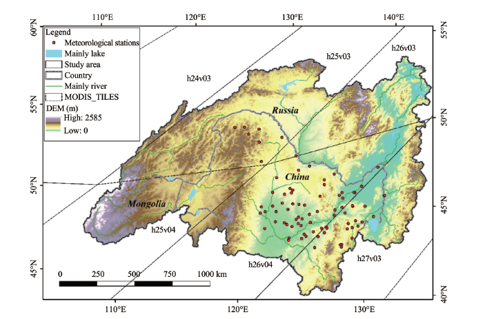
XiaoLin Lu1,WanChang Zhang1( ),ShuHang Wang2,Bo Zhang2,QuanFu Niu3,JinPing Liu1,4,Hao Chen1,4,HuiRan Gao1,4
|
Chang AT, Rango A, 2000. Algorithm theoretical basis document (ATBD) for the AMSR-E snow water equivalent algorithm. NASA/GSFC, 11: 1-49. DOI: 10.1506/car.25.2.3.
doi: 10.1506/car.25.2.3 |
|
|
Chen H, Zhang WC, Gao HR, et al., 2018. Climate change and anthropogenic impacts on wetland and agriculture in the Songnen and Sanjiang plain, northeast china. Remote Sensing, 10(3): 365. DOI: 10.3390/rs10030356.
doi: 10.3390/rs10030356 |
|
| Chu D, 2016. Spatial-temporal variations of snow cover on the Tibet autonomous region from 2000 to 2014 using MODIS. Data. Plateau and Mountain Meteorology Research, 1: 27-37. (in Chinese) | |
|
Dietz AJ, Kuenzer C, Conrad C, 2013. Snow-cover variability in central Asia between 2000 and 2011 derived from improved MODIS daily snow-cover products. International Journal of Remote Sensing, 34(11-12): 3879-3902. DOI: 10.1080/01431161. 2013.767480.
doi: 10.1080/01431161. 2013.767480 |
|
|
Foster JL, Hall DK, Kelly RE, et al., 2009. Seasonal snow extent and snow mass in South America using SMMR and SSM/I passive microwave data (1979-2006). Remote Sensing of Environment, 113: 291-305. DOI: 10.1016/j.rse. 2008.09.010.
doi: 10.1016/j.rse. 2008.09.010 |
|
|
Gafurov A, Bárdossy A, 2009. Cloud removal methodology from MODIS snow cover product. Hydrology and Earth System Sciences, 13: 1361-1373. DOI: 10.5194/hess-13-1361-2009.
doi: 10.5194/hess-13-1361-2009 |
|
|
Gao HR, Nie N, Zhang WC, et al., 2020. Monitoring the spatial distribution and changes in permafrost with passive microwave remote sensing. ISPRS Journal of Photogrammetry and Remote Sensing, 170(2020): 142-155. DOI: 10.1016/j.isprsjprs.2020.10.011.
doi: 10.1016/j.isprsjprs.2020.10.011 |
|
|
Hall D, Riggs G, 2007. Accuracy assessment of the MODIS snow products. Hydrological Processes, 21(12): 1534-1547. DOI: 10.1002/hyp.6715.
doi: 10.1002/hyp.6715 |
|
| Hall D, Riggs G, Salomonson VV, et al., 2001. Algorithm theoretical basis document (ATBD) for the MODIS snow and sea ice-mapping algorithms. MODIS Snow Products User Guide. . | |
|
Hall D, Riggs G, Salomonson VV, et al., 2002. MODIS snow-cover products. Remote Sensing of Environment, 83(1-2): 181-194. DOI: 10.1016/S0034-4257(02)00095-0.
doi: 10.1016/S0034-4257(02)00095-0 |
|
|
Han S, 2014. Methods of flood disaster assessment-taking 2013 flood disaster in Heilongjiang basin as an example. Heilongjiang Science and Technology of Water Conservancy, 7: 63-64. DOI: 10.14122/j.cnki.hskj.2014.07.200. (in Chinese)
doi: 10.14122/j.cnki.hskj.2014.07.200. |
|
|
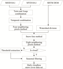
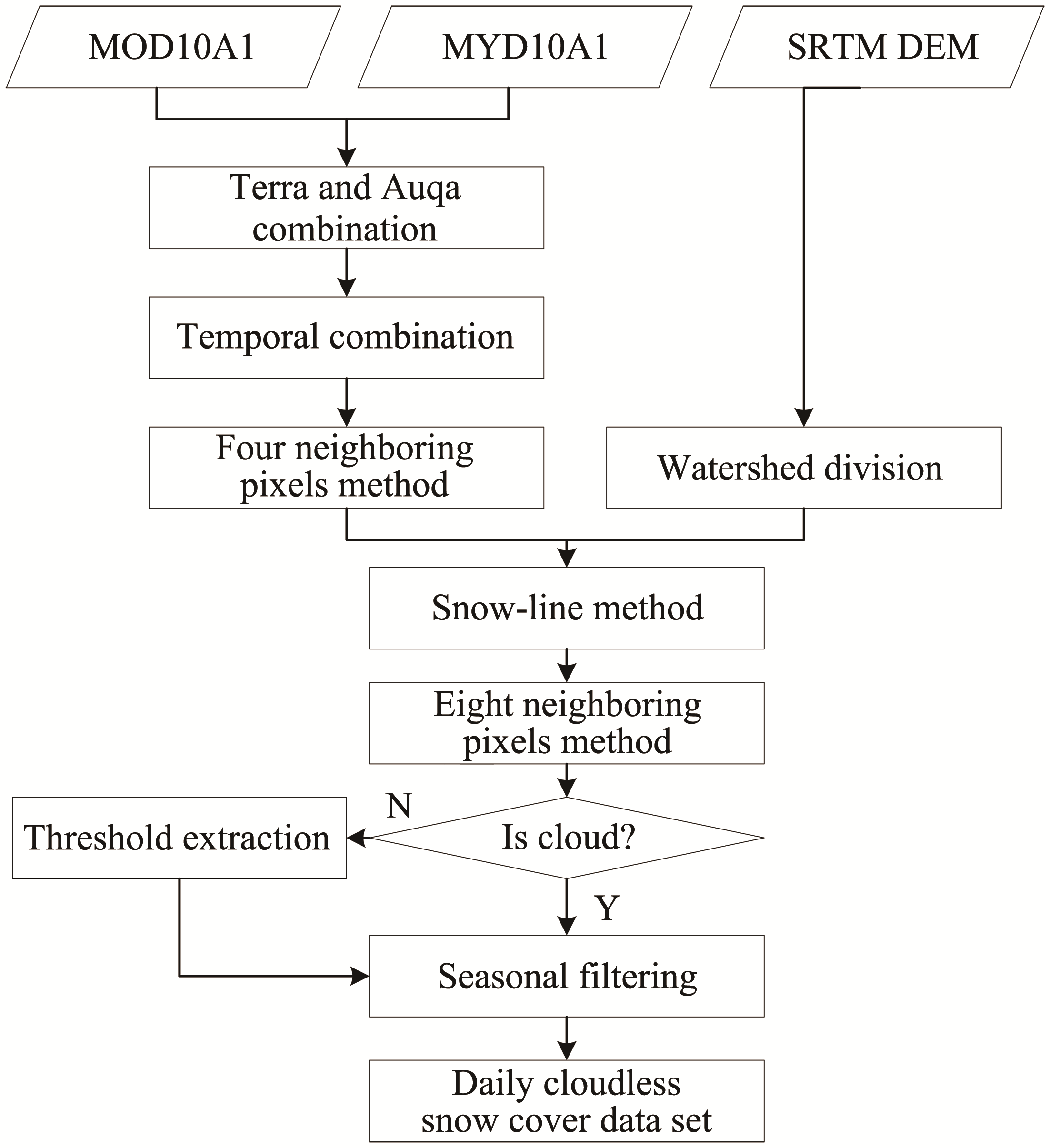
Hou XG, Zheng ZJ, Li S, et al., 2018. Generation of daily cloudless snow cover product in the past 15 years in Xinjiang and accuracy validation. Remote Sensing for Land and Resource, 30(2): 214-222. DOI: 10.6046/gtzyyg.2018.02. 29. (in Chinese)
doi: 10.6046/gtzyyg.2018.02. 29. |
|
|
Huang XD, Hao XH, Wang W, et al., 2012. Algorithms for cloud removal in MODIS daily snow products. Journal of Glaciology and Geocryology, 34(5): 1118-1126. DOI: 10. 1007/s11783-011-0280-z. (in Chinese)
doi: 10. 1007/s11783-011-0280-z. |
|
|
Huang YF, Li TJ, et al., 2017. Amur river basin-world geograpbic data encyclopedia. Journal of Global Change Data & Discovery, 1(1): 101-114. DOI: 10.3974/geodp.2017.01.18. (in Chinese)
doi: 10.3974/geodp.2017.01.18. |
|
|
Jiang LM, Wang P, Zhang LY, et al., 2014. Improvement of snow depth retrieval for FY3B-MWRI in China. Science China (Earth Sciences), 57(6): 1278-1292. DOI: 10.1007/s11430-013-4798-8.
doi: 10.1007/s11430-013-4798-8 |
|
| Labazhuoma, Cizhen, 2018. Snow cover variation and meteorology factor research in Yarlung Zangbo basin of Tibet from 2002 to 2015. Remote Sensing Technology and Application, 33(3): 508-519. (in Chinese) | |
| Liu JP, Zhang WC, Deng C, 2018. Spatiotemporal variations of snow cover over Yarlung Zangbo River Basin in Tibet from 2000 to 2014 and its response to key climate factors. Journal of Glaciology and Geocryology, 40(4): 643-654. (in Chinese) | |
|
Liu JP, Zhang WC, Liu T, 2017. Monitoring recent changes in snow cover in Central Asia using improved MODIS snow-cover products. Journal of Arid Land, 9: 763-777. DOI: 10.1007/s40333-017-0103-6.
doi: 10.1007/s40333-017-0103-6 |
|
|
Parajka J, Blöschl G, 2006. Validation of MODIS snow cover images over Austria. Hydrology and Earth System Sciences Discussions, 10: 679-689. DOI: 10.5194/hess-10-679-2006.
doi: 10.5194/hess-10-679-2006 |
|
|
Paudel KP, Andersen P, 2011. Monitoring snow cover variability in an agropastoral area in the Trans Himalayan region of Nepal using MODIS data with improved cloud removal methodology. Remote Sensing of Environment, 115: 1234-1246. DOI: 10.1016/j.rse.2011.01.006.
doi: 10.1016/j.rse.2011.01.006 |
|
| Qiu YB, Zhang H, Chu D, et al., 2017. Cloud removing algorithm for the daily cloud free MODIS-based snow cover product over the Tibetan Plateau. Journal of Glaciology and Geocryology, 39(3): 515-526. (in Chinese) | |
|
Rittger K, Painter TH, Dozier J, 2013. Assessment of methods for mapping snow cover from MODIS. Advances in Water Resources, 51: 367-380. DOI: 10.1016/j.advwatres.2012. 03.002.
doi: 10.1016/j.advwatres.2012. 03.002 |
|
|
Rosenthal W, Dozier J, 1996. Automated mapping of montane snow cover at subpixel resolution from the Landsat thematic mapper. Water Resources Research, 32(1): 115-130. DOI: 10.1029/95wr02718.
doi: 10.1029/95wr02718 |
|
| Simonov EA, Dahmer TD, 2008. Amur-Heilong river basin reader. Ecosystems Hongkong: 2008. | |
| Sun XR, Gao Y, Din YL, et al., 2019. Distribution and trend of snow cover in Inner Mongolia from 2001 to 2016 based on MODIS data. Arid Zone Research, 36(1):104-112. (in Chinese) | |
| Tang ZG, Wang J, Wang Y, et al., 2017. Extraction and spatiotemporal analysis of snow cover days over Tibetan Plateau based on MODIS data. Mountain Research, 35(3): 412-419. (in Chinese) | |
|
Wang H, Arslan AN, Pulliainen J, et al., 2001. Microwave emission model for wet snow by using radiative transfer and strong fluctuation theory-abstract. Journal of Electromagnetic Waves & Applications, 15: 57-59. DOI: 10.1163/156939301X00634.
doi: 10.1163/156939301X00634 |
|
| Wang J, Che T, Li Z, et al., 2018. Investigation on snow characteristics and their distribution in China. Advance in Earth Science, 33(1): 12-26. (in Chinese) | |
|
Wang XW, Xie H, 2009. New methods for studying the spatiotemporal variation of snow cover based on combination products of MODIS Terra and Aqua. Journal of Hydrology, 371: 192-200. DOI: 10.1016/j.jhydrol.2009.03.028.
doi: 10.1016/j.jhydrol.2009.03.028 |
|
|
Wang XW, Xie H, Liang T, 2008. Evaluation of MODIS snow cover and cloud mask and its application in Northern Xinjiang, China. Remote Sensing of Environment, 112: 1497-1513. DOI: 10.1016/j.rse.2007.05.016.
doi: 10.1016/j.rse.2007.05.016 |
|
|
Wang XW, Zhu Y, Chen Y, et al., 2017. Influences of forest on MODIS snow cover mapping and snow variations in the Amur River basin in Northeast Asia during 2000-2014. Hydrological Processes, 31: 3225-3241. DOI: 10.1002/hyp. 11249.
doi: 10.1002/hyp. 11249 |
|
| Wang YJ, Zuo HJ, Liu BH, 2017. Research progress on temporal and spatial distribution of snow cover in China. Journal of Inner Mongolia Forestry Science & Technology, 43(3): 47-51. (in Chinese) | |
|
Xie H, Wang XW, Liang T, 2009. Development and assessment of combined Terra and Aqua snow cover products in Colorado Plateau, USA and northern Xinjiang, China. Journal of Applied Remote Sensing, 3(1): 1319-1332. DOI: 10. 1117/1.3265996.
doi: 10. 1117/1.3265996 |
|
| Yang ZG, Da W, Chu D, et al., 2017. Spatiotemporal variations of snow cover on the Tibetan Plateau over the last 15 years. Remote Sensing Technology and Application, 32(1): 27-36. (in Chinese) | |
| Yu LX, Zhang SW, Guan C, et al., 2014. Monitoring on spatial and temporal changes of snow cover in the Heilongjiang Basin Based on remote sensing. Chinese Journal of Applied Ecology, 25(9): 2521-2528. (in Chinese) | |
|
Zhao H, Fernandes R, 2009. Daily snow cover estimation from advanced very high-resolution radiometer polar pathfinder data over northern hemisphere land surfaces during 1982-2004. Journal of Geophysical Research, 114(D5): D05113. DOI: 10.1029/2008jd011272.
doi: 10.1029/2008jd011272 |
| [1] | Jing Li,ShiYin Liu,Qiao Liu. MODIS observed snow cover variations in the Aksu River Basin, Northwest China [J]. Sciences in Cold and Arid Regions, 2019, 11(3): 208-217. |
| [2] | Zhuo Ga, Tao Chen, La Ba, PuBuCiRen, Ba Sang. Distribution of winter-spring snow over the Tibetan Plateau and its relationship with summer precipitation in Yangtze River [J]. Sciences in Cold and Arid Regions, 2017, 9(1): 20-28. |
|