Sciences in Cold and Arid Regions ›› 2021, Vol. 13 ›› Issue (6): 474–487.doi: 10.3724/SP.J.1226.2021.20094
• • 上一篇
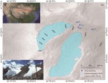
High-precision measurements of the inter-annual evolution for Urumqi Glacier No.1 in eastern Tien Shan, China
ChunHai Xu1,2( ),ZhongQin Li1,JianXin Mu1,PuYu Wang1,FeiTeng Wang1
- 1.State Key Laboratory of Cryospheric Science/Tien Shan Glaciological Station, Northwest Institute of Eco-Environment and Resources, Chinese Academy of Sciences, Lanzhou, Gansu 730000, China
2.National Cryosphere Desert Data Center, Northwest Institute of Eco-Environment and Resources, Chinese Academy of Sciences, Lanzhou, Gansu 730000, China


|
Abermann J, Fischer A, Lambrecht A, et al., 2010. On the potential of very high-resolution repeat DEMs in glacial and periglacial environments. The Cryosphere, 4: 53-65. DOI: 10.5194/tc-4-53-2010.
doi: 10.5194/tc-4-53-2010 |
|
|
Benoit L, Gourdon A, Vallat R, et al., 2019. A high-resolution image time series of the Gorner Glacier-Swiss Alps-derived from repeated unmanned aerial vehicle surveys. Earth System Science Data, 11(2): 579-588. DOI: 0.5194/essd-11-579-2019.
doi: 0.5194/essd-11-579-2019 |
|
|
Besl P, Neil DM, 1992. A method for registration of 3-D shapes. IEEE Transactions on Pattern Analysis and Machine Intelligence, 14: 239-256. DOI: 10.1109/34.121791.
doi: 10.1109/34.121791 |
|
|
Brun F, Berthier E, Wagnon P, et al., 2017. A spatially resolved estimate of High Mountain Asia glacier mass balances from 2000 to 2016. Nature Geoscience, 10: 668-673. DOI: 10.1038/NGEO2999.
doi: 10.1038/NGEO2999 |
|
| CH/Z3017-2015, 2015. Technical Specifications for Three-dimensional Laser Scanning, National Administration of Surveying, Mapping and Geo-information of the People's Republic of China, Beijing, China. pp.1-17. (in Chinese) | |
|
Che Y, Wang S, Yi S, et al., 2020. Summer mass balance and surface velocity derived by unmanned aerial vehicle on debris-covered region of Baishui River Glacier No.1, Yulong Snow Mountain. Remote Sensing, 12(20): 1-15. DOI: 10.3390/rs12203280.
doi: 10.3390/rs12203280 |
|
|
Ding Y, Zhang S, Zhao L, et al., 2019. Global warming weakening the inherent stability of glaciers and permafrost. Science Bulletin, 64(4): 245-253. DOI: 10.1016/j.scib.2018.12.028.
doi: 10.1016/j.scib.2018.12.028 |
|
|
Farinotti D, Longuevergne L, Moholdt G, et al., 2015. Substantial glacier mass loss in the Tien Shan over the past 50 years. Nature Geoscience, 8: 716-722. DOI: 10.1038/NGEO2513.
doi: 10.1038/NGEO2513 |
|
|
Fey C, Wichmann V, 2017. Long-range terrestrial laser scanning for geomorphological change detection in alpine terrain-handling uncertainties. Earth Surface Processes and Landforms, 42(5): 789-802. DOI: 10.1002/esp.4022.
doi: 10.1002/esp.4022 |
|
|
Fischer M, Huss M, Kummert M, et al., 2016. Application and validation of long-range terrestrial laser scanning to monitor the mass balance of very small glaciers in the Swiss Alps. The Cryosphere, 10(3): 1279-1295. DOI: 10.5194/tc-10-1279-2016.
doi: 10.5194/tc-10-1279-2016 |
|
|
Fugazza D, Scaioni M, Corti M, et al., 2018. Combination of UAV and terrestrial photogrammetry to assess rapid glacier evolution and map glacier hazards. Natural Hazards and Earth System Sciences, 18(4): 1055-1071. DOI: 10.5194/nhess-18-1055-2018.
doi: 10.5194/nhess-18-1055-2018 |
|
|
Gabbud C, Micheletti N, Lane SN, 2015. Lidar measurement of surface melt for a temperate Alpine glacier at the seasonal and hourly scales. Journal of Glaciology, 61(229): 963-974. DOI: 10.3189/2015JoG14J226.
doi: 10.3189/2015JoG14J226 |
|
|
Gindraux S, Boesch R, Farinotti D, 2017. Accuracy assessment of digital surface models from unmanned aerial vehicles' imagery on glaciers. Remote Sensing, 9(2): 1-15. DOI: 10.3390/rs9020186.
doi: 10.3390/rs9020186 |
|
|
Guo W, Liu S, Xu J, et al., 2015. The second Chinese glacier inventory: data, methods and results. Journal of Glaciology, 61(226): 357-372. DOI: 10.3189/2015JoG14J209.
doi: 10.3189/2015JoG14J209 |
|
| Haeberli WI, 1995. Glacier fluctuations and climate change detection. Geografia Fisica e Dinamica Quaternaria, 18: 191-199. | |
|
Immerzeel WW, Kraaijenbrink PD, et al., 2014. High-resolution monitoring of Himalayan glacier dynamics using unmanned aerial vehicles. Remote Sensing of Environment, 150: 93-103. DOI: 10.1016/j.rse.2014.04.025.
doi: 10.1016/j.rse.2014.04.025 |
|
|
Joerg PC, Morsdorf F, Zemp M, 2012. Uncertainty assessment of multi-temporal airborne laser scanning data: A case study on an Alpine glacier. Remote Sensing of Environment, 127: 118-129. DOI: 10.1016/j.rse.2012.08.012.
doi: 10.1016/j.rse.2012.08.012 |
|
| Li P, Yan M, Xu Y, et al., 2012. Calculation methods of glacier terminus variation Based on GIS: a case study on Austre Lovénbreen in Arctic. Journal of Glaciology and Geocryology, 34(2): 367-367. (in Chinese) | |
|
Li Z, Li H, Chen Y, 2011. Mechanisms and simulation of accelerated shrinkage of continental glaciers: a case study of Urumqi Glacier No. 1 in eastern Tianshan, Central Asia. Journal of Earth Science, 22(4): 423-430. DOI: 10.1007/s12583-011-0194-5.
doi: 10.1007/s12583-011-0194-5 |
|
| Liang S, 1983. Type glacier-I hot-water ice auger and its application. Journal of Glaciology and Geocryology, 5(4): 91-95. (in Chinese) | |
|
Lichti DD, Gordon SJ, Tipdecho T, 2005. Error models and propagation in directly georeferenced terrestrial laser scanner networks. Journal of Surveying Engineering, 131(4): 135-142. DOI: 10.1061/(ASCE)0733-9453.
doi: 10.1061/(ASCE)0733-9453 |
|
|
López MJI, Revuelto J, Rico I, et al., 2016. Thinning of the Monte Perdido Glacier in the Spanish Pyrenees since 1981. The Cryosphere, 10: 681-694. DOI: 10.5194/tc-10-681-2016.
doi: 10.5194/tc-10-681-2016 |
|
|
Marzeion B, Kaser G, Maussion F, et al., 2018. Limited influence of climate change mitigation on short-term glacier mass loss. Nature Climate Change, 8(4): 305-308. DOI: 10.1038/s41558-018-0093-1.
doi: 10.1038/s41558-018-0093-1 |
|
|
Perroy RL, Bookhagen B, Asner GP, et al., 2010. Comparison of gully erosion estimates using airborne and ground-based LiDAR on Santa Cruz Island, California. Geomorphology, 118(3-4): 288-300. DOI: 10.1016/j.geomorph.2010.01.009.
doi: 10.1016/j.geomorph.2010.01.009 |
|
|
Piermattei L, Carturan L, Guarnieri A, 2015. Use of terrestrial photogrammetry based on structure-from-motion for mass balance estimation of a small glacier in the Italian Alps. Earth Surface Processes and Landforms, 40(13): 1791-1802. DOI: 10.1002/esp.3756.
doi: 10.1002/esp.3756 |
|
| Ren, J, Zhang J, Huang M, 1985. A study of the ice temperature in No. 1 glacier in the Urumqi River headwaters, Tianshan. Journal of Glaciology and Geocryology, 7(2): 141-152. (in Chinese) | |
|
Revuelto J, López-Moreno JI, Azorin-Molina C, et al., 2014. Mapping the annual evolution of snow depth in a small catchment in the Pyrenees using the long-range terrestrial laser scanning. Journal of Maps, 10(3): 379-393. DOI: 10.1080/17445647.2013.869268.
doi: 10.1080/17445647.2013.869268 |
|
| RIEGL Laser Measurement Systems, 2014. 3D terrestrial laser scanner Riegl VZ®-4000/Riegl VZ®-6000 General Description and Data Interfaces. Horn, Austria: RIEGL Laser Measurement Systems. | |
|
Rippin DM, Pomfret A, King N, 2015. High resolution mapping of supra-glacial drainage pathways reveals link between micro-channel drainage density, surface roughness and surface reflectance. Earth Surface Processes and Landforms, 40(10): 1279-1290. DOI: 10.1002/esp.3719.
doi: 10.1002/esp.3719 |
|
|
Rolstad C, Haug T, Denby B, 2009. Spatially integrated geodetic glacier mass balance and its uncertainty based on geostatistical analysis: application to the western Svartisen ice cap, Norway. Journal of Glaciology, 55(192): 666-680. DOI: 10.3189/002214309789470950.
doi: 10.3189/002214309789470950 |
|
|
Schnabel R, Klein R, 2006. Octree-based point-cloud compression, in: Proceedings of Eurographics Symposium on Point Based Graphics, Boston, MA, USA, 111-120. DOI: 10.2312/SPBG/SPBG06/111-120.
doi: 10.2312/SPBG/SPBG06/111-120 |
|
|
Schumann GJ, Bates PD, 2018. The need for a high-accuracy, open-access global DEM. Frontiers in Earth Science, 6: 1-5. DOI: 10.3389/feart.2018.00225.
doi: 10.3389/feart.2018.00225 |
|
|
Shangguan D, Liu S, Ding Y, et al., 2010. Changes in the elevation and extent of two glaciers along the Yanglonghe river, Qilian Shan, China. Journal of Glaciology, 56(196): 309-317. DOI: 10.3189/002214310791968566.
doi: 10.3189/002214310791968566 |
|
|
Silverio W, Jaquet JM, 2005. Glacial cover mapping (1987-1996) of the Cordillera Blanca (Peru) using satellite imagery. Remote Sensing of Environment, 95(3): 342-350. DOI: 10.1016/j.rse.2004.12.012.
doi: 10.1016/j.rse.2004.12.012 |
|
|
Sorg A, Bolch T, Stoffel M, et al., 2012. Climate change impacts on glaciers and runoff in Tien Shan (Central Asia). Nature Climate Change, 2(10): 725-731. DOI: 10.1038/NCLIMATE1592.
doi: 10.1038/NCLIMATE1592 |
|
|
Sommer C, Malz P, Seehaus TC, et al., 2020. Rapid glacier retreat and downwasting throughout the European Alps in the early 21st century. Nature Communications, 11(1): 1-10. DOI: 10.1038/s41467-020-16818-0.
doi: 10.1038/s41467-020-16818-0 |
|
|
Thibert E, Blanc R, Vincen C, et al., 2008. Glaciological and volumetric mass-balance measurements: error analysis over 51 years for Glacier de Sarennes, French Alps. Journal of Glaciology, 54(186): 522-532. DOI: 10.3189/002214308785837093.
doi: 10.3189/002214308785837093 |
|
|
Thomson L, Copland L, 2016. White Glacier 2014, Axel Heiberg Island, Nunavut: mapped using structure from motion methods. Journal of Maps, 12(5): 1063-1071. DOI: 10.1080/17445647.2015.1124057.
doi: 10.1080/17445647.2015.1124057 |
|
|
Wang P, Li Z, Li H, et al., 2017. Characteristics of a partially debris-covered glacier and its response to atmospheric warming in Mt. Tomor, Tien Shan, China. Global and Planetary Change, 159: 11-24. DOI: 10.1016/j.gloplacha.2017.10.006.
doi: 10.1016/j.gloplacha.2017.10.006 |
|
|
Wang P, Li Z, Li H, et al., 2016. Analyses of recent observations of Urumqi Glacier No. 1, Chinese Tianshan mountains. Environmental Earth Sciences, 75(8): 1-11. DOI: 10.1007/s12665-016-5551-3.
doi: 10.1007/s12665-016-5551-3 |
|
|
WGMS (World Glacier Monitoring Service), 2020. Fluctuations of Glaciers Database. World Glacier Monitoring Service, Zurich, Switzerland. DOI: 10.5904/wgms-fog-2020-08.
doi: 10.5904/wgms-fog-2020-08 |
|
|
Xu C, Li Z, Li H, et al., 2019. Long-range terrestrial laser scanning measurements of annual and intra-annual mass balances for Urumqi Glacier No. 1, eastern Tien Shan, China. The Cryosphere, 13(9): 2361-2383. DOI: 10.5194/tc-13-2361-2019.
doi: 10.5194/tc-13-2361-2019 |
|
|
Xu C, Li Z, Wang P, et al., 2018. Detailed comparison of glaciological and geodetic mass balances for Urumqi Glacier No. 1, eastern Tien Shan, China, from 1981 to 2015. Cold Regions Science and Technology, 155: 137-148. DOI: 10.1016/j.coldregions.2018.08.006.
doi: 10.1016/j.coldregions.2018.08.006 |
|
|
Zemp M, Thibert E, Hus, et al., 2013. Reanalysing glacier mass balance measurement series. The Cryosphere, 7: 1227-1245. DOI: 10.5194/tc-7-1227-2013.
doi: 10.5194/tc-7-1227-2013 |
|
|
Zhang Z, 1994. Iterative point matching for registration of free-form curves and surfaces. International Journal of Computer Vision, 13(2): 119-152. DOI: 10.1007/BF01427149.
doi: 10.1007/BF01427149 |
|
| Zhu G,1982. Type B-1 experimental radar instation for measuring the thickness of glaciers. Journal of Glaciology and Geocryology, 4(2): 93-95. (in Chinese) |
| No related articles found! |
|
||