Sciences in Cold and Arid Regions ›› 2019, Vol. 11 ›› Issue (6): 419–427.doi: 10.3724/SP.J.1226.2019.00419.
• •
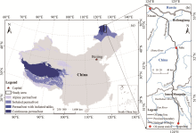
Relationship between ponding and topographic factors along the China-Russia Crude Oil Pipeline in permafrost regions
MingTang Chai1,YanHu Mu1( ),GuoYu Li1,Wei Ma1,Fei Wang1,2
- 1. State Key Laboratory of Frozen Soil Engineering, Northwest Institute of Eco-Environment and Resources, Chinese Academy of Sciences, Lanzhou, Gansu 730000, China
2. University of Chinese Academy of Sciences, Beijing 100049, China


|
Beven KJ , Kirkby MJ , 1979. A physically based, variable contributing area model of basin hydrology. Hydrological Sciences Journal, 24(1): 43-69. DOI: 10.1080/02626667909 491834 .
doi: 10.1080/02626667909 491834 |
|
|
Beven KJ , Kirkby MJ , Schofield N , et al. , 1984. Testing a physically-based flood forecasting model (TOPMODEL) for three UK catchments. Journal of Hydrology, 69(1-4): 119-143. DOI: 10.1016/0022-1694(84)90159-8 .
doi: 10.1016/0022-1694(84)90159-8 |
|
| Chen QL , 2007. Engineering geological research on the permafrost in high latitudes area and its impact on pipeline construction. Thesis. Chinese Academy of Geological Sciences, pp. 17-29. (in Chinese) | |
|
Cheng GD , Jin HJ , 2013. Permafrost and groundwater on the Qinghai-Tibet Plateau and in northeast China. Hydrogeology Journal, 21(1): 5-23. DOI: 10.1007/s10040-012-0927-2 .
doi: 10.1007/s10040-012-0927-2 |
|
| Gu ZW , Zhou YW , Liang FX , et al. , 1993. Permafrost features and their changes in Amur area, Da Xing'an Ling Prefecture. Journal of Glaciology and Geocryology, 15(1): 34-40. (in Chinese) | |
|
Hunter GJ , Michael FG , 1997. Modeling the uncertainty of slope and aspect estimates derived from spatial databases. Geographical Analysis, 29(1): 35-49. DOI: 10.1111/j.1538-4632.1997.tb00944.x .
doi: 10.1111/j.1538-4632.1997.tb00944.x |
|
|
Jenson SK , Domingue JO , 1988. Extracting topographic structure from digital elevation data for geographic information system analysis. Photogrammetric Engineering and Remote Sensing, 54(11): 1593-1600. DOI: 10.1.1.138.6487 .
doi: 10.1.1.138.6487 |
|
|
Jin, HJ, Hao JQ , Chang XL , et al. , 2010. Zonation and assessment of frozen-ground conditions for engineering geology along the China-Russia crude oil pipeline route from Mo'he to Daqing. Northeastern China. Cold Regions Science and Technolog, 64: 213-225. DOI: 10.1016/j.coldregions.2009.12.003 .
doi: 10.1016/j.coldregions.2009.12.003 |
|
|
Jin HJ , Yu QH , Lü LZ , et al. , 2007. Degradation of permafrost in the Xing'anling Mountains, Northeastern China. Permafrost and Periglacial Processes, 18(3): 245-258. DOI: 10. 1002/ppp.589 .
doi: 10. 1002/ppp.589 |
|
|
Li GY , Ma W , Wang XL , et al. , 2015. Frost hazards and mitigative measures following operation of Mohe-Daqing line of China-Russia crude oil pipeline. Rock and Soil Mechanics, 36(10): 2963-2973. DOI: 10.16285/j.rsm.2015.10.030 . (in Chinese)
doi: 10.16285/j.rsm.2015.10.030 |
|
|
Li GY , Wang F , Ma W , et al. , 2018. Field observations of cooling performance of thermosyphons on permafrost under the China-Russia Crude Oil Pipeline. Applied Thermal Engineering, 141: 688-696. DOI: 10.1016/j.applthermaleng. 2018.06.005 .
doi: 10.1016/j.applthermaleng. 2018.06.005 |
|
|
Liu JJ , Xie J , 2013. Numerical simulation of thermo-hydro-mechanical coupling around underground pipelines in patchy permafrost region. Rock and Soil Mechanics, 34(1): 444-450. DOI: 10.16285/j.rsm.2013.s1.032 . (in Chinese)
doi: 10.16285/j.rsm.2013.s1.032 |
|
|
Martz LW , Garbrecht J , 1999. An outlet breaching algorithm for the treatment of closed depressions in a raster DEM. Computers & Geosciences, 25(7): 835-844. DOI: 10.1016/S0098-3004(99)00018-7 .
doi: 10.1016/S0098-3004(99)00018-7 |
|
|
Mu YH , Ma W , Li GY , et al. , 2018. Impacts of supra-permafrost water ponding and drainage on a railway embankment in continuous permafrost zone, the interior of the Qinghai-Tibet Plateau. Cold Regions Science and Technology, 154: 23-31. DOI: 10.1016/j.coldregions.2018.06.007 .
doi: 10.1016/j.coldregions.2018.06.007 |
|
|
O'Callaghan JF , David MM , 1984. The extraction of drainage networks from digital elevation data. Computer Vision, Graphics, and Image Processing, 28(3): 323-344. DOI: 10.1016/S0734-189X(84)80011-0 .
doi: 10.1016/S0734-189X(84)80011-0 |
|
|
Persson A , Pilesjö P , Eklundh L , 2005. Spatial influence of topographical factors on yield of potato (Solanum tuberosum L.)in central Sweden. Precision Agriculture, 6(4): 341-357. DOI: 10.1007/s11119-005-2323-6 .
doi: 10.1007/s11119-005-2323-6 |
|
|
Quinn P , Beven K , Chevallier P , et al. , 1991. The prediction of hillslope flow paths for distributed hydrological modelling using digital terrain models. Hydrological processes, 5(1): 59-79. DOI: 10.1002/hyp.3360050106 .
doi: 10.1002/hyp.3360050106 |
|
|
Sørensen R , Seibert J , 2007. Effects of DEM resolution on the calculation of topographical indices: TWI and its components. Journal of Hydrology, 347(1-2): 79-89. DOI: 10.1016/j.jhydrol.2007.09.001 .
doi: 10.1016/j.jhydrol.2007.09.001 |
|
|
Strahler AN , 1957. Quantitative analysis of watershed geomorphology. Eos. Transactions American Geophysical Union, 38(6): 913-920. DOI: 10.1029/TR038i006p00913 .
doi: 10.1029/TR038i006p00913 |
|
|
Tang GA , Hui YH , Josef S , et al. , 2001. The impact of resolution on the accuracy of hydrologic data derived from DEMs. Journal of Geographical Sciences, 11(4): 393-401. DOI: 10.1007/BF02837966 .
doi: 10.1007/BF02837966 |
|
|
Vincent L , Soille P , 1991. Watersheds in digital spaces: an efficient algorithm based on immersion simulations. IEEE Transactions on Pattern Analysis & Machine Intelligence, 6: 583-598. DOI: 10.1109/34.87344 .
doi: 10.1109/34.87344 |
|
|
Wang F , Li GY , Ma W , et al. , 2018. Permafrost thawing along the China-Russia Crude Oil Pipeline and countermeasures: A case study in Jiagedaqi, Northeast China. Cold Regions Science and Technology, 155: 308-313. DOI: 10.1016/j.coldregions.2018.08.018 .
doi: 10.1016/j.coldregions.2018.08.018 |
|
|
Wei Z , Jin HJ , Zhang JM , et al. , 2011. Prediction of permafrost changes in Northeastern China under a changing climate. Science China Earth Sciences, 54(6): 924-935. DOI: 10. 1007/s11430-010-4109-6 .
doi: 10. 1007/s11430-010-4109-6 |
|
|
Wen Z , Zhelezniak M , Wang DY , et al. , 2018. Thermal interaction between a thermokarst lake and a nearby embankment in permafrost regions. Cold Regions Science and Technology, 155: 214-224. DOI: 10.1016/j.coldregions.2018.08.010 .
doi: 10.1016/j.coldregions.2018.08.010 |
|
| Wood J , 1996. The geomorphological characterisation of digital elevation models. Leicester: University of Leicester, pp. 110-115. | |
|
Wu S , Li J , Huang GH , 2008. A study on DEM-derived primary topographic attributes for hydrologic applications: Sensitivity to elevation data resolution. Applied Geography, 28(3): 210-223. DOI: 10.1016/j.apgeog.2008.02.006 .
doi: 10.1016/j.apgeog.2008.02.006 |
|
|
Xia YL , Li XJ , Wang T , 2018. A Hybrid Flow Direction Algorithm for Water Routing on DEMs. Acta Geodaetica et Cartographica Sinica, 47(5): 683-691. DOI: 10.11947/j.AGCS.2018.20170614 . (in Chinese)
doi: 10.11947/j.AGCS.2018.20170614 |
|
| Zhang CX , Yang QK , Li R , 2005. Advancement in topographic wetness index and its application. Progress in Geography, 24(6): 116-123. (in Chinese) | |
|
Zhao XJ , 2013. Analysis of rivers hydrological characteristics and variation in the Da Hinggan Mountains. Water Resources & Hydropower of Northeast, 31(5): 41-44. DOI: 0.14124/j.cnki.dbslsd22-1097.2013.05.002 . (in Chinese)
doi: 0.14124/j.cnki.dbslsd22-1097.2013.05.002 |
|
|
Zhou QM , Liu XJ , 2004. Analysis of errors of derived slope and aspect related to DEM data properties. Computers & Geosciences, 30(4): 369-378. DOI: 10.1016/j.cageo.2003. 07.005 .
doi: 10.1016/j.cageo.2003. 07.005 |
| No related articles found! |
|
||