In the last two decades, assessing the current state and predicting the future evolution of permafrost under climate change have become research topics of high priority in many countries. High-mountain permafrost environments are unique in that geocryological conditions in rugged terrain can vary over very short distances, from a few meters to hundreds of meters, at the same altitude. This pattern is due to the influence of local factors, both natural and anthropogenic, which include slope aspect, tectonics, and insulating and/or cooling effects of building foundations. This paper presents a study in the Zhosalykezen Pass in the Ili Alatau Range, Northern Tien Shan, to illustrate and discuss these relationships.
The Zhosalykezen Pass lies on the divide between the Prokhodnaya River and Ozernaya River catchments (the Bolshaya Almatinka River Basin) at an altitude of 3,336 m. Here, in the early 1950s, the Lebedev Institute of Physics, USSR Academy of Sciences, constructed buildings for its Tien Shan alpine station. It was mistakenly assumed from pre-construction observations in shallow test pits that the area had only seasonal frost, and a heated brick building was erected on a strip footing without any regard for permafrost. As a result, the building showed the first signs of deformation within a decade. Because of the problems caused by permafrost, the Permafrost Institute of the USSR Academy of Sciences initiated geocryological studies in this area in 1962.
Important data were collected during those early studies, mainly from a 50-m-long adit excavated in permafrost beneath a gentle east-facing slope at an altitude of 3,300 m a.s.l.. A 3-m borehole was drilled from the adit face. In 1962, ground temperature in this borehole was measured to be −0.8 °C at a depth of 18 m from the slope surface. The thickness of permafrost was about 25~30 m. This estimate was the first of permafrost thickness for the Zhosalykezen Pass area. Another borehole, 27 m deep, penetrated into bedrock (granite) from the depth of 24 m. The temperature at the bottom of the hole was about 0 °C, while the thickness of the permafrost was around 30~35 m. The depth of seasonal thaw in the pass area varied from 3.3 to 4.7 m.
The permafrost layer penetrated by the adit contained boulders comprising 5%~10% by volume. The remainder consisted of rubble and fines. The bulk density of frozen ground varied from 1.39 to 2.24 g/cm3.
The Zhosalykezen Pass is located in crush zones of two merging tectonic faults that run east–west across the pass between the Prokhodanaya and Ozernaya valleys (Kulikovskiy, 1971; Zhdanovich, 2003). Zones of crushing (mylonitization) and taliks adjacent to these faults divide the permafrost into separate masses (Severskiy et al., 2014 ).
At present, there are several buildings and facilities on the Zhosalykezen Pass located within an area of about 3 km2. Temperature boreholes were drilled in Upper Pleistocene and Holocene coarse morainal material, approximately 20~25 m thick, underlain by granitic rocks. The moraines have volumetric ice contents, varying from 5% to 40%, and cryostructures classified as porous-massive and thick-lenticular (Gorbunov et al., 1996 ).
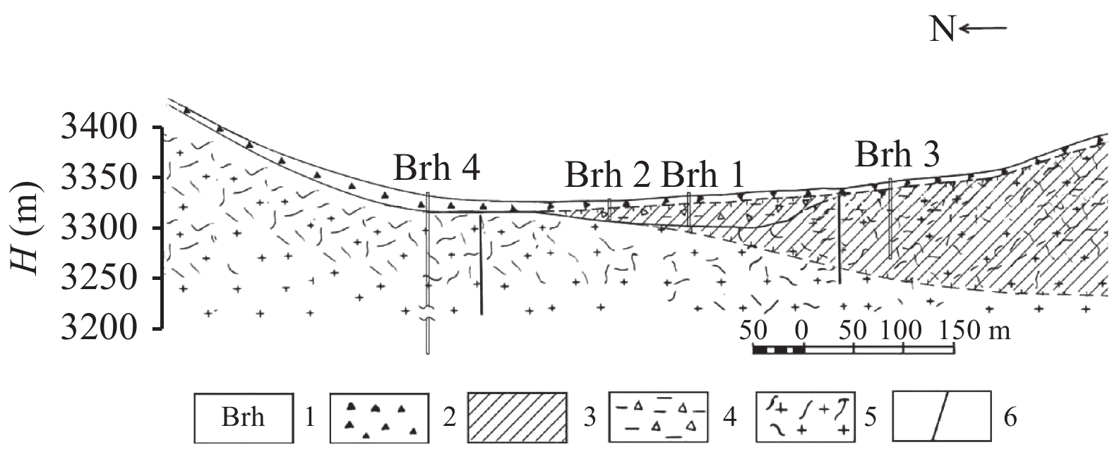
The geology and tectonics of the Zhosalykezen Pass were first shown by Filatov et al. (1967) in a geological cross section derived from geophysical measurements. This information provided a basis for our geocryological investigations to determine the general patterns of permafrost distribution and thickness variation over a distance of about 500 m (Figure 1).

|
Figure 1 A geological and permafrost cross section of the Zhosalykezen Pass: 1, temperature borehole number; 2, slope deposits; 3, permafrost; 4, coarse, blocky morainal deposits with sand and silt fines; 5, bedrock (granites); and 6, tectonic fault |
At the foot of the northern slope, the thickness of permafrost was determined to be about 100 m (Figure 1, borehole 3). In 200 m, in the fault zone at the flat saddle of the pass, the permafrost thickness decreases to 35~40 m (borehole 1). At 80 m distant (borehole 2), it further decreases to 13 m; there, until 1987, a heated building founded on a strip footing added a warming effect to the seismogenic factor. On the south-facing slope, 200 m away from borehole 2, drilling data showed no permafrost (Figure 1, borehole 4).
2 MethodsSince 1974, the Kazakhstan Alpine Permafrost Laboratory of the Melnikov Permafrost Institute has been conducting systematic, year-round observations at monitoring-network sites established in the Zhosalykezen Pass area for thermal monitoring of permafrost, active layer, and seasonally frozen ground. These sites are the only source of information on the thermal regime of perennial and seasonal frost and its changes, both in the study area and generally in the mountains of Central Asia. In 2013, geophysical studies were undertaken by a team led by V. V. Olenchenko from the Trofimuk Institute of Petroleum Geology and Geophysics in Novosibirsk, using the electrical resistivity tomography modification of vertical electrical sounding. The electrical sounding profile was conducted along the pass crest from the south- to the north-facing slope along the borehole line. The profile traversed both the undisturbed and the built-up areas.
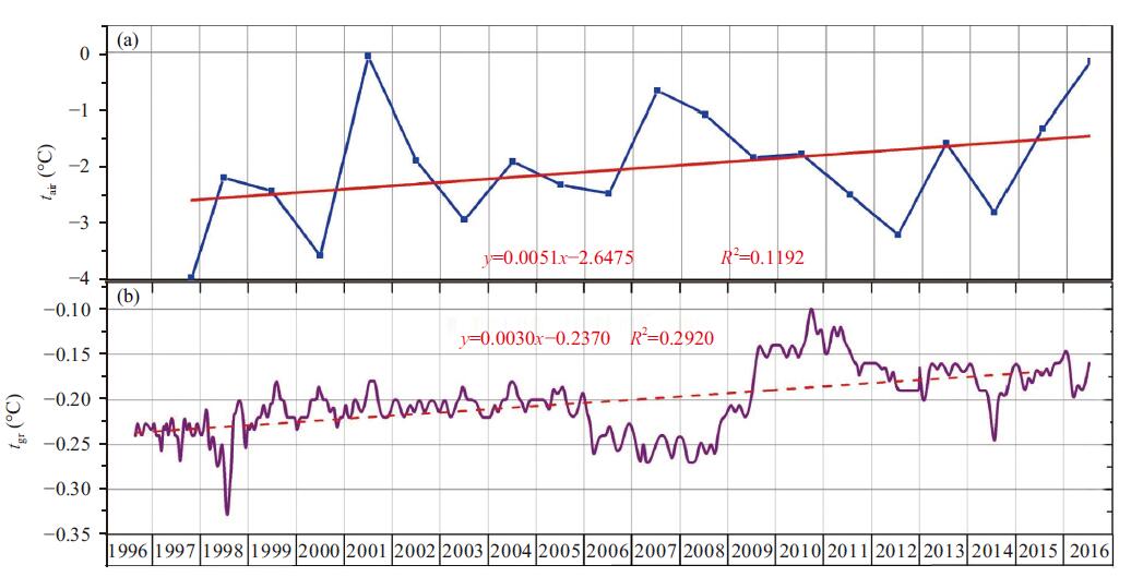
3 ResultsIn the early period of geothermal monitoring in the Zhosalykezen Pass area (1974), permafrost temperatures at the depth of zero annual amplitude (13~17 m) varied from −0.4 to −0.8 °C. In the following twenty years, the ground temperatures increased in all boreholes by 0.2~0.5 °C (Gorbunov et al., 1996 ). Between 1995 and 2016, the temperatures have remained within −0.2 to −0.25 °C, with small variations (Figure 2).

|
Figure 2 Variations in air temperature tair (a) and permafrost temperature tgr (b) at 20-m depth in borehole 1 |
In general, the permafrost temperatures exhibit a weak increasing trend (0.01 °C/a) over the 40-year period. If this trend continues, the permafrost is expected to have a gradient-free thermal regime and temperatures close to 0 °C during the next 20~30 years (Severskiy, 2011).
The climatic conditions in the pass area for the initial observation period (1973–1975) were as follows: mean annual air temperature −3.9 °C, January mean −14.2 °C, and August mean +6.4 °C. By 2003, these values had increased by 0.4, 0.5, and 0.3 °C, respectively, i.e., the rate of temperature increase was 0.01~0.02 °C/a. The frost-free season is absent in the area, and frosts down to −5 or −6 °C may occur even in June. Snow cover develops in October and persists until the beginning of June.
Observations indicate that the climate in the high mountains of the Northern Tien Shan has been warming over the last 70 years. A trend of 0.02 °C/a increase in mean annual air temperature has been observed at the Tuyuksu-1 (3,450 m a.s.l.) and Mynzhylki (3,017 m a.s.l.) weather stations during this period (Piven, 2007). All across the Tien Shan Mountains, glaciers have been rapidly degrading since the early 1970s in response to the warming climate (Severskiy, 2016).
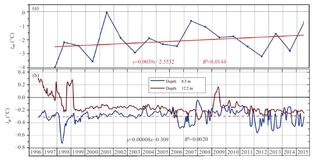
The permafrost temperature regime and thickness are affected to some extent by a seismic factor. The Northern Tien Shan has high seismic activity, with strong earthquakes occurring regularly in the region. Earthquakes can cause increased heat flux from the earth's interior through tectonic faults. In particular, the most likely explanation for the reduced permafrost thicknesses, 12~13 m in borehole 2 and 35~40 m in borehole 1 (Figure 1), is that these areas are located near or within the zone of tectonic faults. In the area of borehole 2, for example, occasional increases in permafrost temperature are observed during the periods of high seismic activity, at times crossing 0 °C near the permafrost bottom at a depth of 12.2 m (Figure 3).

|
Figure 3 Variations in air temperature tair (a) and ground temperature tgr (b) at depths of 8.3 m and 12.2 m in borehole 2 |
In October 2011 and January 2013, for example, a 0.10~0.18 °C increase in ground temperature was observed 2~3 days after earthquakes of intensity 2 and 4 on the MSK-64 scale, reported by the Kazakhstan Institute of Seismology. Later, as the seismic activity decayed, temperature at this depth decreased again and restored to the pre-earthquake values (−0.27 and −0.29 °C).
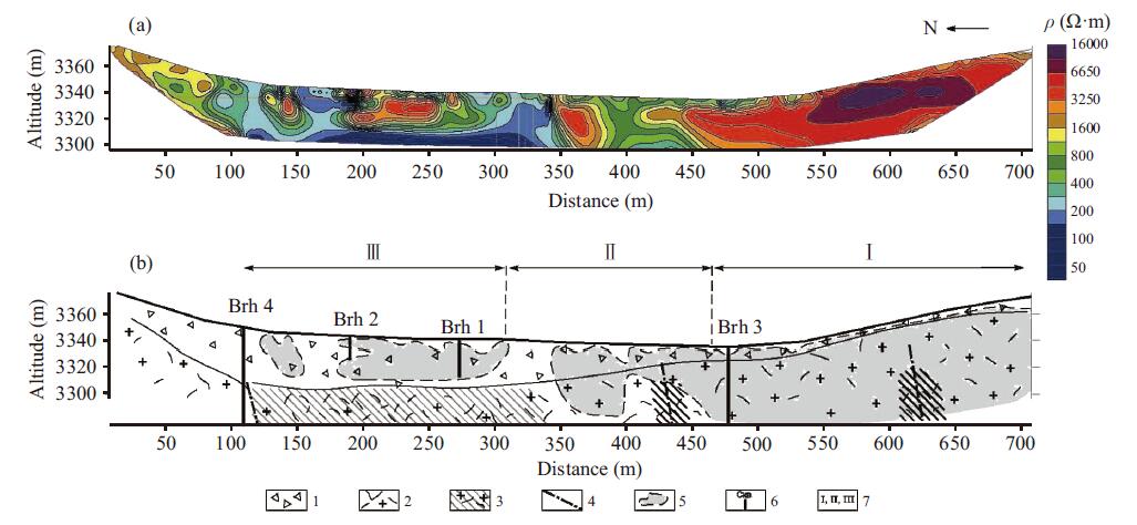
The variation in the thickness and distribution of permafrost is clearly reflected on a geoelectric section (Figure 4a).

|
Figure 4 Geoelectric section for the Zhosalykezen Pass (a) and its interpretation (b). 1, Slope and morainal deposits; 2, fractured granites; 3, zones of crushing and mylonitization; 4, tectonic disturbances; 5, permafrost; 6, projection of thermal boreholes onto ERT profile; and 7, areas with different types of permafrost distribution: I continuous, II discontinuous, III sporadic; Brh relates to temperature borehole |
The results of electrical soundings in the Zhosalykezen Pass indicated that the layer of high resistivity associated with permafrost has a reduced thickness and is discontinuous or sporadic in areal extent in the junction of intersecting tectonic disturbances. The higher temperatures measured in the monitoring boreholes during earthquakes allow us to attribute the reduced thickness and the sporadic extent of permafrost in the saddle of Zhosalykezen to the warming effect of heat flow through the fault.
Obviously, the tectonic influence on permafrost distribution is superimposed on the effect of the transition from a north-facing to a south-facing slope. The electrical sounding data (Figure 4) indicate that, against the background of a general decrease in permafrost thickness, the character of permafrost changes locally, with a change in slope aspect in the tectonic disturbance zones.
According to the resistivity distribution along the profile line, areas of continuous (I), discontinuous (II), and sporadic (III) permafrost can be identified in a south-to-north direction (Figure 4b). The high-resistivity layer exhibits a consistent change both in structure (from continuous to discontinuous and sporadic) and in resistivity values. The change in resistivity with the transition from continuous to sporadic permafrost is related to the increase in temperature and the decrease in permafrost thickness.
Thus, the geoelectric model derived shows good agreement with the distribution and characteristics of permafrost in the Zhosalykezen Pass, inferred from analysis of long-term ground temperature measurements.
Human activities have a significant impact on the pattern of permafrost distribution. Borehole 2 (Figure 1) was located approximately 3 m from a heated brick building erected in the 1970s on a strip footing, neglecting the permafrost conditions. With time, the permafrost temperature progressively increased and the active-layer deepened, resulting in thaw-bulb development beneath the building. This induced differential thaw settlement of the ground, causing growing damage to the building. The building deteriorated badly over the years and was demolished in 1986~1987.
As the warming effect from the building was eliminated, the permafrost began to aggrade to its natural conditions. From 1995 to the present, its temperature has remained within −0.2 to −0.3 °C (Figure 3), which is similar to the natural permafrost temperatures (Figure 2).
Another single-story building on a strip footing that stands in front of the demolished house is now undergoing deformations (Figure 5a).

|
Figure 5 Buildings on permafrost undergoing deformation: on a strip footing (a) and on a pile foundation (c); and geoelectric sections (b, d) |
The largest ground settlement is observed in the southern part of the building, where the wall is heated more. In addition, the permafrost temperature is close to 0 °C due to the proximity to a tectonic fault; and even the slightest disturbance of the heat balance leads to permafrost degradation and talik development in the foundation. Another zone with anomalously low resistivities interpreted as a talik was detected beneath the asphalt-covered pad and road (Figure 5b).
A building that was constructed on a pile foundation with an air space below the floor—with the intent of preserving the permafrost—is also experiencing deformations (Figure 5c). The problems show up in the form of settlement cracks on the facade up to 2 cm wide. Cracks may have developed due to the variation in bearing capacity in the foundation soils or due to the seismic impacts. Most likely, however, they are the results from the integrated effect of both factors.
Newly formed permafrost was identified under the northern, shaded part of the building, while the ground on the southern side exposed to the sun was interpreted to be thawed (Figure 5d). The frozen and thawed foundation materials have different physicomechanical characteristics, and seismic impacts may lead to differential structural deformation and cracking. A snow shed installed on the windward side was intended to prevent drifting of snow into the ventilated air space below the building. The shed, however, accumulates a large amount of snow, as much as 3~4 m in height, along the wall during winter. Snow drifts insulate the ground surface, resulting in a talik that is clearly indicated on the resistivity section by a local low-resistivity anomaly (Figure 5d).
4 ConclusionsForty years of ground-temperature observations in the Zhosalykezen Pass area indicate no significant trend in permafrost temperature in response to current climate warming, with the rate of temperature increase as low as 0.01 °C/a. This suggests that the permafrost in the northern Tien Shan is relatively stable thermally to changes in climate.
The effects of local factors on the distribution, temperature, and thickness of permafrost in the Zhosalykezen Pass area were determined. These factors include slope aspect, tectonic faulting, and human activities.
The results indicate that the type of permafrost-distribution changes naturally found with transition from a north-facing to a south-facing slope. The continuous permafrost on the north-facing slope is characterized by high resistivity values (4,500~11,000 Ω·m and a thickness of about 100 m. Drilling data indicate the absence of permafrost on the southern slope, and this is confirmed by low resistivities (780~1,600 Ω·m).
The effect of tectonics is manifested in the discontinuous and/or sporadic distribution of permafrost in the junction of faults on the horizontal saddle of the pass. The geoelectric section here becomes variable, with resistivity values ranging from 780 to 5,000 Ω·m. Also, temperature increases at the permafrost bottom, occasionally rising above 0 °C, occur in this zone during seismic events. The thickness of permafrost here is reduced from 40 to 13 m.
The anthropogenic effect on permafrost structure in the Zhosalykezen Pass is expressed by the ground's warming and increased active-layer thickness beneath the heated buildings on strip footings. This foundation design did not provide for maintaining the permafrost and has resulted in thaw bulbs and taliks, which are indicated on the geoelectric sections by low-resistivity anomalies.
Talik development was revealed by geophysical data within the snow shed zone, where snow drifts have an insulating effect. Signs of new permafrost formation were detected beneath the building on a pile foundation, where the near-surface ground showed an increase in resistivity.
Thus, geophysical studies using the Electrical resistivity tomography (ERT) method have helped detail the morphology of permafrost in the Zhosalykezen Pass and assess the effects of local factors on its spatial extent.
In a changing climate, the complexity of permafrost conditions and distribution in mountainous terrain demands increased requirements to developmental activities, especially to construction of engineering works.
Filatov LG, Rovenskiy MI, Tuzov VA, et al., 1967. Methodology for integrated geophysical investigations in application to hydrological and engineering geological studies of mudslide-prone areas, Bolzhaya and Malaya Almatinka basins. In: Proceedings of Workshop on Application of Geophysical and Mathematical Methods in Engineering-Geology and Hydrogeology, Vol. 5, pp. 159–171. (in Russian)
|
Gorbunov AP, Severskiy EV, Titkov SN, 1996. Geocryological Conditions of the Tien Shan and Pamir. Yakutsk: Permafrost Institute Press, pp. 194. (in Russian)
|
Kulikovskiy KT. 1971. On the origin of mountain lakes in the Issyk and Bolshaya Almatinka basins and their mudflow control role. Materials on Geology and Mineral Resources, 4(29): 259-271. |
Piven EN. 2007. Current climatic changes in the glacial-nival zone of southeastern Kazakhstan (long-term observations data). Terra, 2: 52-61. |
Severskiy EV, 2011. Geothermal monitoring of permafrost in the Northern Tien Shan. In: Proceedings of the Fourth Conference of Russian Geocryologists, Vol. 2, parts 5–6. Moscow: Universitetskaya Kniga, pp. 154–161. (in Russian)
|
Severskiy EV, Olenchenko VV, Gorbunov AP. 2014. Influence of local factors on the structure of permafrost, Zhosalykezen Pass (North Tien Shan). Kriosfera Zemli, 18(4): 13-22. |
Severskiy IV, 2016. Change in glaciation of the Balkash-Alakol basin over the last 60 years and its effect on streamflow and water resources. In: Medeu AR (ed.). Proceedings of International Conference, Water Resources of Central Asia and Their Use. Almaty, pp. 403–417. (in Russian)
|
Zhdanovich AR. 2003. Bolshoe Almatinskoe Lake and the seismic-destruction-thrust hypothesis for its origin. Proceedings of the National Academy of Sciences of the Republic of Kazakhstan, series of geology and technical sciences, 6: 94-108. |
 2017, Vol. 9
