 2017, 9
Article Information
- Irina Chesnokova, Dmitry Sergeev . 2017.
- Complex analysis of the damage caused by geocryologic processes (as exemplified by effects on the Chara-China Railway track, Transbaikal region)
- Sciences in Cold and Arid Regions, 9(3): 335-338
- http://dx.doi.org/10.3724/SP.J.1226.2017.00335
Article History
- Received: November 21, 2016
- Accepted: December 21, 2016


2. Institute of Environmental Geoscience, Russian Academy of Sciences, 13 Ulansky per., Moscow 101000, Russia
Regular monitoring of the geological environment is an indispensable source of information on natural and natural-technogenic processes and makes it possible to reveal the natural laws of development of those processes (a basic science problem), as well as to solve problems related to safe management in the permafrost zone (a practical mission).
The assessment of natural hazards requires an integrated approach that can reveal the natural dynamics of geocryologic conditions and help to explain the causes of the change in activity of geocryologic processes. Simultaneously, in addition to the characteristics of geocryologic conditions (rock temperature, depth of seasonal thawing, etc.), we should constantly observe related factors (climate and microclimate, land covers, the moistening regime, and temporary anthropogene influence).
2 Assessment of economic damage to the railway trackThe study area is situated in the Stanovoy upland and contains both mountain areas with an absolute altitude up to 2,200 m and intermountain depressions, the largest of them being the Upper Chara depression, with an absolute altitude at the lowest point of about 700 m. The air temperature in the depression has demonstrated two stages of sharp warming (in the late 1980s and at the beginning of the first decade of the 21st century (Karausheva, 1977; Zheleznyak, 2005; Pavlov, 2008)), conjugated with subsequent temporary periods of weak cooling periods in 1989 to 2001 and in 2003. The north Trans-Baikal region refers to areas with evident climate warming that will affect geocryologic conditions. In Chara, though the average increasing rate of the average annual air temperature had been about 0.3 °C per decade for 50 years, this tendency has not been evident in the most recent 30 years in spite of a clear increase in the magnitude of positive anomalies (Figure 1) (Perlestain and Sergeev, 2012).

|
| Figure 1 Average annual air temperature at the weather bureau (hereafter, average values are given for the period from September to August): (1) Chara meteobureau; (2) linear trend for the 1959~2013 period, according to the Chara meteobureau; (3) linear trend for the 1987~2013 period, according to the Chara meteobureau |
Data previously obtained suggested regional permafrost warming observed at a depth affected by seasonal temperature fluctuations. This pattern might be associated with the development of other processes (e.g., thermokarst, river erosion, ice formation, heave moulds, dynamics of glaciers; evolution of vegetation communities, hydrological regime of water objects).
The Chara-China Railway branch was built in 2001, with a view to selecting industrial sites for the construction of the Chiney copper mining and processing plant. The cost of the railway was 6.8 billion rubles (nearly 95 million rubles per 1 km of track). It should be noted that, in addition to having copper, the Chiney deposit is the largest in Russia in reserves and potential resources of V-bearing titanomagnetite ores; and, in vanadium resources, this site is the largest in the world. For three years (1998 to 2001) 20.4 million m3 of earthwork was carried out in conditions of high seismicity (9 on the Richter scale), complicated relief (the steepness of slopes is 35°~45°), high soil-ice content, active development of mudflows, avalanches and rock glaciers in the territory.
In complexity, this road has no analogue in the practice of railway construction in Russia. Even the Baikal-Amur road cedes to the Chara-China Railway in the complexity of construction, not to mention the large volume of work completed under a tight schedule. For the Chara-China branch, 20 bridges (3 viaducts), 2.1 km of retaining walls, 2.8 km of indoor and outdoor galleries, 77 rectangular concrete and corrugated metallic culverts, and 20 filtering mounds have been erected.
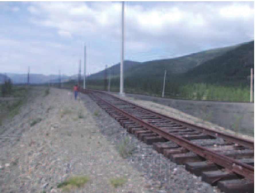
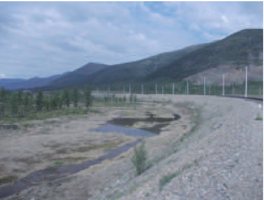
What has happened to the road during 15 years? Intensive undermining of track panels has occurred. In many places, there is a complete absence of the shoulder ballast—rails are hanging in the air; in certain places, rails are covered by sedimentary rocks and bedrock. Poles along the road are bulging (Figures 2 and 3).

|
| Figure 2 and 3 Disturbances in the zone of the railway track where fieldwork is ongoing. Measuring and describing of disturbances, which appeared due to the development of dangerous geocryological processes (2014, photo by Sergeev, Chesnokova) |
What have the authors done? They used a unique, massive collection of data for analyzing the cumulative effect of the geocryologic processes on the 75-kilometer Chara-China track (the Kolar district of the Transbaikal region) in the absence of repairs or protective and compensatory measures during a long period of time (13 years). Table 1 gives a data fragment related to development factors and characteristics of the phenomena associated with hazardous geocryologic processes along the route of the Chara-China Railway. This table represents a fragment of the data obtained in field conditions.
| Point N | Picket | Coordinate | Railway track | Railway land area | Adjacent area | Vegetation, notes |
| I'7 | 5 | Subsidence centre 56.495418 118.6865 Н = 1.553 m. | Deep subsidence of the fill and railway track conical. Curved poles; subsidence length, 100 m.
|
The left part is eroded and waterlogged on the right, the area is waterlogged
|
The lake on the right accepts discharge from the waterlo- gged area | Left of the railway, close to the road: a low-lying willow-cotton, grass-sedge (black sedge) bog |
Assessment of economic damage to the railway track. To assess the damage, the disturbed parts on the track were investigated. It is known that during repair (when the construction of the track is returned to the design framework, the roadbed and drainage structures get restored), the cost of 1 meter (km) can be valued in rubles. Therefore, with the data presented in Table 2, we can assess the approximate damage (in rubles), and that can be done for different conditions-simple, medium, and complex.
| No. | General length of the damage (m) | Subsidence depth (m) | Volume | Estimated cost of ground work, rubles (750 rubles for m3) | Estimated cost of track repairs (2009 prices) | Number of damaged points for km | ||
| Simple (1 m for 19,700 rubles | Medium (1 m for 32,100 rubles) | Complex (1 m for 41,077 rubles) | ||||||
| 1 | 60 | 0.5 | 165.00 | 123,750 | 1,182,000 | 1,926,000 | 2,464,620 | 1 |
| 2 | 0 | 0.0 | 0.00 | 0 | 0 | 0 | 0 | 0 |
| 3 | 25 | 0.4 | 55.00 | 41,250 | 492,500 | 802,500 | 1,026,925 | 1 |
| 4 | 53 | 4.7 | 832.91 | 624,683 | 1,044,100 | 1,701,300 | 2,177,081 | 2 |
| 5 | 0 | 0.0 | 0.00 | 0 | 0 | 0 | 0 | 0 |
| 6 | 0 | 0.0 | 0.00 | 0 | 0 | 0 | 0 | 0 |
| 7 | 26 | 0.3 | 42.90 | 32,175 | 512,200 | 834,600 | 1,068,002 | 1 |
| 8 | 0 | 0.0 | 0.00 | 0 | 0 | 0 | 0 | 0 |
| 9 | 0 | 0.0 | 0.00 | 0 | 0 | 0 | 0 | 0 |
| 10 | 17 | 0.3 | 28.05 | 21,038 | 334,900 | 545,700 | 698,309 | 1 |
| 11 | 50 | 0.2 | 41.25 | 30,938 | 985,000 | 1,605,000 | 2,053,850 | 1 |
| 12 | 100 | 0.1 | 55.00 | 41,250 | 1,970,000 | 3,210,000 | 4,107,700 | 1 |
The authors also analyzed the economic damage on the main geomorphological areas along the Chara-China track. Results are given in Table 3.
| Relief type | Significance of economic damage (rubles, 2009 prices) | ||
| Minimum | Medium | Maximum | |
| Chara River Valley | 3,230,800 | 5,264,400 | 6,736,628 |
| Piedmont tails | 16,390,400 | 26,707,200 | 34,176,064 |
| Sortan moraine | 5,299,300 | 8,634,900 | 11,049,713 |
| Highland area | 4,363,550 | 7,110,150 | 9,099,556 |
| Intermountain zone | 24,239,950 | 39,595,350 | 50,668,480 |
Knowing the value of the damage and the probability of its happening, we can try to define the insurance rates and even approach definition of the insurance index that shows the degree of risk and the value of the insurance rate.
Along the route, 53 points were chosen with various deformations that evoke economic damage. Here, nine damage gradations were identified (Table 4).
| Damage (thousands) | Damage category | Cases (km) | Probability share |
| 0 | 1 | 21 | 0.40 |
| 0~200 | 2 | 21 | 0.40 |
| 200~400 | 3 | 2 | 0.04 |
| 400~600 | 4 | 4 | 0.08 |
| 600~800 | 5 | 1 | 0.02 |
| 800~1,000 | 6 | 1 | 0.02 |
| 1,000~1,200 | 7 | 1 | 0.02 |
| 1,200~1,400 | 8 | 1 | 0.02 |
| 1,400~1,600 | 9 | 1 | 0.02 |
Field and cameral works along the Chara-China route were carried out by the authors in this investigation. Unique data on the total impact of dangerous geocryological processes on the 75-km Chara-China Railway track (northern Transbaikal region) in the absence of repair work, protective and compensating measures during a long interval of time (13 years) have been obtained. For the first time, economic damage was assessed that was caused by dangerous geocryological processes on the this road. Based on the data obtained, the authors were able to approach the definition of insurance tariffs. The done work allows to speak about an insurance index of the studied territory which shows degree of risk and size of an insurance rate. In 2007, it was declared that reconstruction of the railway had been included in the Railway Transport Development Strategy to occur before 2030, which was approved by the Government of the Russian Federation.
Acknowledgment:The investigation was completed with financial support of the Russian Fund of Basic Researches #16-05-00200.