Article Information
- A. Harris Stuart . 2016.
- Identification, characteristics and classification of cryogenic block streams
- Sciences in Cold and Arid Regions, 8(3): 177-186
- http://dx.doi.org/10.3724/SP.J.1226.2016.00177.
Article History
- Received: March 10, 2016
- Accepted: May 11, 2016
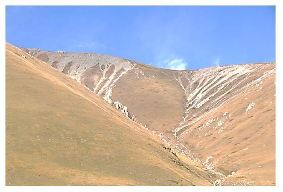
Block streams consist of a stream of blocks on sloping hillsides resembling a stream deposit, usually on gully floors or slightly lower areas (Washburn, 1979; White, 1981). The angle of slope is greater than 10°, but less than the maximum angle of repose of these sediments (Romanovsky and Tyurin, 1986). Synonyms include stone runs (Darwin, 1839), Blokströme (Büdel, 1937), rock streams (Kesserli, 1941), and rubble streams (Richmond, 1962). However, the term ∀rock stream∀ is also applied to rock glaciers. In Russia, block streams are referred to as kurums. Figure 1 shows a typical example from the eastern slopes of the Qinghai-Tibet Plateau, China. Romanovsky (1985) provided a typical block diagram of those found in Yakutia, Siberia. They represent a good example of landforms exhibiting equifinality, i.e., where similar-looking landforms are produced by different processes in dissimilar climates. Although they do not necessarily occur in areas of present-day permafrost, the blocky surfaces of all block streams can produce the diode effect on the ground temperature profile beneath them (Romanovsky and Tyurin, 1986; Harris, 1994).
|
| Figure 1 Block streams descending from a talus slope near Maqú (34°2'N, 102°30'E), eastern slopes of the Qinghai-Tibetan Plateau at 4, 300 m |
Cryogenic block streams refer to those formed in areas of permafrost, e.g., northern Siberia and the northeastern Qinghai-Tibet Plateau. In this paper, the main characteristics of cryogenic block streams are described, followed by a genetic classification of the active, dynamic block streams and descriptions of contrasting dynamic, lag, and relict block streams. It is based on field studies in China and North America, and published descriptions of block streams in Tasmania, the Falkland Islands, Germany, North America, China, Japan, and Russia. There is a considerable body of literature available. Although the earlier studies suggest a wide variety of origins in the case of the stone runs in the Falkland Islands in particular, recent studies have provided critical evidence to allow this review of the currently available evidence for their origin.
2 CharacteristicsActive block streams consist of a stream of blocks forming a river of rocks extending downslope, often along a gully floor. The slope usually exceeds 10° but is less than the maximum angle of repose of the blocks, implying that some process or processes besides gravity is involved in the movement of the rocks. The source of the blocks varies from angular/subangular stones coming from frost-shattered bedrock (Loziński, 1912; Demek, 1960), lahars or debris flows (Matsumoto, 1970), or from frost-jacking of clasts from tills on the Qinghai-Tibet Plateau (Harris et al., 1998). Corestones remaining from removal of the interstitial weathering products from past warmer climates have been described as forming block streams in Tasmania (Caine, 1968a; 1968b; 1972; 1983)and the Falkland Islands (André et al., 2008), and are also present at Felsen, Germany (Büdel, 1937; Hövermann, 1949). The constituent blocks vary from small angular stones ejected from till by frost-jacking or frost-shattered bedrock (Harris et al., 1998) , up to large boulders over 2 m in length as at Felsen in Germany. These large boulders exhibit a subrounded to rounded shape, suggesting that they represent corestones produced by tropical weathering left by erosion of the interstitial finer sediment. A column, carved by the Romans from one of the blocks shows little sign of frost action in spite of surviving two cold Neoglacial events during the last 2, 000 year (Felsenmeer-Reichenbach, https://commons.wikimedia.org/File:Felsenmeer_Reisenbach_Riesendaeule_03jpg). Matsumoto (1970) summarizes the range of processes suggested for Japanese block streams.
In actively-forming block streams, either the blocks move while the underlying sediment remains relatively stationary (herein called dynamic block streams), or the blocks may remain relatively stationary while the interstitial sediment is removed by running water (lag block streams). In the latter case, an alluvial fan is normally found at the terminus of the block stream, composed of material washed out from the matrix of the block stream. Block streams represent positive or negative landforms, depending on whether they override the underlying sediments or are found in gullies or depressions in the landscape, respectively. Those blocks which move downslope normally show a fabric with the long axes of the blocks forming a primary mode indicating the direction of movement (Caine, 1968b; Harris et al., 1998). The lag blocks either show the fabric of the parent material, or an essentially random fabric in the case of some corestones left from tropical or subtropical weathering.
Blocks in dynamic block streams produced by frost-shattering of bedrock commonly have a roundness of 0.4 to 0.8 on the Krumbein scale (Krumbein, 1941), whereas blocks in lag block streams exhibit a roundness of 0.3 to 0.4 near the Chinese Upper Glaciological Station south of Urumqi, based on the measurement of the shape of 100 randomly chosen clasts. Possible corestones commonly exhibit even greater roundness, e.g. 0.5-0.8 at Felsen.
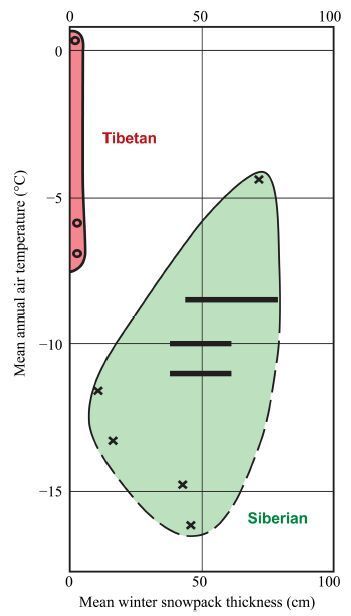
In Tibet, the ice content in winter in the actively moving blocks consists of a thin coating of ice formed by the melting and refreezing of a thin dusting of snow. In Siberia, burial by up to 45 cm of snow in winter results in the formation, diurnal thawing, and refreezing of interstitial ice and ice lenses. Actual yearly movement of individual blocks has been measured as being as high as 120 cm in Tibet, although the average movement of the stones is 20 cm/a. Thickness of the layer of blocks varies from a single layer up to 50 cm or more.
In Siberia, the thickness of the block streams varies from under 30 cm near the Arctic Ocean to 4 m in south-central Siberia. Unfortunately, there are no data on rates of movement from the latter. Vegetation is normally lacking on all active dynamic block streams, in contrast to the surrounding tundra. Lag block streams are usually covered in lichens and occasionally partially by trees, indicating that they have remained stationary while the interstitial sediment is washed away. It should also be noted that lag block streams can also be formed under cold conditions lacking permafrost (Hack and Goodlett, 1960; Dahl, 1966; Ives, 1966; Rapp, 1967).
The occurrence of all types of actively forming block streams is controlled by the climate, lithological characteristics of the solid rock or the composition of the unconsolidated deposits, the ruggedness of the terrain, and the tectonic features of the area (Romanovsky and Tyurin, 1986), but have not been reported as forming in warm temperate to tropical climatic conditions. Changing climate can result in cessation of the formative processes if the block stream becomes buried by other sediment or by an ice advance (Kleman and Borgström, 1990; Marquette et al., 2004). Where buried relict block streams become exposed at the surface, renewal of the washing-out of the interstitial sediment may take place, regardless of the local climatic conditions, provided there is water moving through them. Careful study of relict block streams often provides evidence for a complex history of the evolution of the climate and landscape at that particular location which may span millions of years, especially in the Southern Hemisphere.
3 ClassificationTable 1 shows a genetic classification of actively forming block streams using the currently available data. Cryogenic block streams can be active or relict. As noted above, the actively-developing block streams can be divided into two groups, viz., those dynamic block streams where the blocks actually move downslope, and the lag block streams in which relict blocks remain stationary while the interstitial material is slowly removed by flowing water, primarily in the spring.
| Property | Dynamic cryogenic block streams | Lag cryogenic block streams | |
| Tibetan | Siberian | ||
| Location | Tongues descending from cliffs over other slope deposits | In gullies and on narrow valley floors, usually ending in alluvial fans | |
| Source of the blocks | Till or bedrock | Bouldery till, rock glaciers, rocky sediments | |
| Roundness (Krumbein scale) | 0.17 to 0.2 | No data | 0.3 to 0.4 |
| Lichens present | No | Well-developed except on limestones | |
| Positive or negative landforms | Positive | Negative | |
Cryogenic dynamic block streams result from two distinct sets of processes that are dependent on the climate. The Tibetan dynamic block streams of the Qinghai Tibet Plateau are formed in areas with minimal winter snowfall (Harris et al., 1998), while the Siberian dynamic block streams occur in the Ural mountains and in northern Siberia, where there is more winter precipitation than on the Tibetan Plateau (Romanovsky and Tyurin, 1983; 1986; Romanovsky, 1985; Romanovsky et al., 1989)and the mean annual air temperature (MAAT)is lower (Figure 2). Active dynamic block streams are typically positive landforms, i.e., the blocks are superimposed on the underlying material. Cryogenic lag block streams have been reported from the Chinese Tien Shan Mountains (Harris et al., 1998), and from the more southerly parts of Siberia where the permafrost is relict (Perov, 1969; Tyurin et al., 1982; Romanovsky, 1985). They are found where there is a considerable source of water moving downslope during part of the year, and are almost always found as negative landforms in gullies. However, lag block streams can also be active in cold climates where permafrost is absent, so they are not a reliable indicator of the presence of permafrost under the present climate.
|
| Figure 2 Relation of active Tibetan and Siberian dynamic block streams to both mean annual air temperature and mean depth of the winter snowpack |
Relict block streams are found scattered around the world in a variety of situations. So far, there are too few descriptions and detailed studies to produce a genetic classification. Instead, several examples will be described, showing the wide range of variation in past history of the landscape in which they are found. They occur at scattered locations across North America, Europe, Asia, Australia, and on the Antarctic Peninsula. They usually represent relict deposits formed on the remains of older landscapes, although dating them has only recently been achieved by cosmogenic dating methods (Marquette et al., 2004; Gray et al., 2005). Rea et al. (1996) and Whalley et al. (1997, 2004)have used clay content and thickness of related soils to argue for Pre-Quaternary ages of blockfields in northern Norway. However, the most compelling arguments are based on the underlying sediments, pioneered by Caine (1968a)on the block slopes in Tasmania as discussed below.
3.1 The Siberian type of active dynamic block streams: kurumsThese were first noted by Middendorf (1860) , but detailed studies were not carried out until 1911 (see Romanovsky and Tyurin, 1983). Initially, Loziński (1912) showed that both climate and lithology were closely connected to their area of occurrence in Siberia. They occur as ∀filmy∀ layers about 30-40 cm thick close to sea level in the humid Arctic areas such as the Polar Urals (Matveev, 1963)but become thicker southwards, reaching 1 m thickness in northeast Russia and northern Siberia (Romanovsky and Tyurin, 1986). In central and southern Siberia, they continue to become thicker (up to 4 m thick), although these landforms are relict, being apparently formed during previous cold events corresponding to major glaciations in more humid areas.
Klatka (1962) and Glaznovskji (1978) carried out important studies regarding the formation of the presently active Siberian block streams, showing that they require high humidity as in the Polar Urals. In temperate climates, they reach timberline, but they occur in different climatic belts in each region of Siberia. In Franz Josef Land, they range from 50 to160 m in altitude, whereas in the northern part of the Central Siberian Highland, they are found between 700 and 1, 500 m. In Tuva, they are found between 1, 600 and 3, 500 m. Combined with differences in topography and bedrock, the climate produces different regimes of movement in each area.
Romanvsky and Tyurin (1986) describe in detail the processes involved in kurum movement. All active Siberian kurums owe their movement to a slow settling and downslope movement due to periodic changes in the volume of the interstitial ice between individual blocks. Diurnal temperature changes cause a stirring of the blocks, but result in little downslope movement. However, frost heaving takes place, causing frost creep, complicated by downslope collapse of the blocks as the icy matrix thaws.
Laboratory experiments show that moisture retention by the blocks is good on slopes up to 15°, but results in limited speed of movement due to the low slope angle. Rates of annual movement increase as the slope steepens to 20°, but after that the water flows too rapidly through the interstices in the blocks and the amount of movement on the slopes decreases. Above 40°, gravitational forces take over and the annual movement increases with increasing slope angle (Ospennikov, 1979). Cryogenic deserption (creep)of the blocks results in movement of the blocks as separate entities with a downslope component instead of movement perpendicular to the slope. The movement perpendicular to the slope is only possible at the surface. At depth, the expansion in all directions is impossible due to the lateral space problem. When surface thawing occurs, the icy upper layer thaws first, due to the high thermal conductivity of ice, and this exposes the honeycomb structure in the underlying layers. The thawing front takes the form of the cells, and the fragments of rock slip downslope in their cells (Čigir, 1977). In the Arctic, this collapse is observed every one to two years, whereas in the deeper blocky active layers farther south, it may only occur once in every five or six years.
Freezing of the surface layers of the rock fragments at night results in refreezing of the surface water films on the blocks, resulting in uplift of the enclosed blocks at right angles to the slope. Thawing of these layers by day results in vertical sinking of the blocks at their new, downslope location, unless downslope slumping occurs. The result is a type of diurnal creep. The larger blocks have thicker water films due to their greater thermal conductivity, so they move farther in any given freezing event, but the smaller blocks freeze more often, which may result in greater total movement in a season. Any movement of the lower fragments as they thaw causes all the layers above to move downslope. Thus, the overall movement decreases with depth in the blocky active layer, as in frost creep.
Maximum downslope movement is seen in the Arctic filmy kurums where the entire active layer becomes saturated with ice. Southwards, the thickness of the blocky active layer increases and the zone saturated with ice decreases. The warmer climate to the south is also involved in producing the reduction of movement, though this is less important than the amount of water turning into ice. However, there is a decrease in movement as the thickness of snow pack increases, resulting in open taliks. The usual diode effect occurs where there is a poor snow cover, but is ineffective where the snow is deeper. So far, no intergrades with the Tibetan type of active block stream have been reported, although these are possible.
3.2 The Tibetan type of active dynamic block streamsThese are relatively thin, active block streams found on the eastern parts of the Qinghai-Tibet Plateau at an elevation of 4, 300-5, 100 m. Harris et al. (1998) described a typical case at 4, 800 m in the Kunlun Pass. The block stream consisted of a thin, 15cm-thick layer of blocks, moving down a 31°, west-facing slope at an average rate of 22.6 cm/a. However, the amount of movement varied enormously from block to block, the maximum rate of movement being 105 cm/a. The movement occurred primarily in winter due to the meagre snowfall thawing by day, resulting in the development of an icy coating on individual blocks, or warmer humid air passing over the cold stones. These then tended to slide downslope after any disturbance, including uneven thawing of the icy coating, often rotating as they moved. The movement varied both laterally and longitudinally on the landform. The rates of movement suggest that the block stream originated about 500 years ago at the beginning of the last Neoglacial event. The region is still undergoing uplift at a rate of 6-9 mm/a (Chen et al., 1994).
The blocks originated from two locations, one being a rock outcrop undergoing mechanical weathering by frost action, and the other being stones ejected from glacial till by frost-jacking. These two block streams coalesced to form the main block stream. The diode effect on the ground temperature in the underlying sediment resulted in permafrost being present under the landform, although it was absent in the surrounding soils on this southwest-facing slope (Harris, 1996).
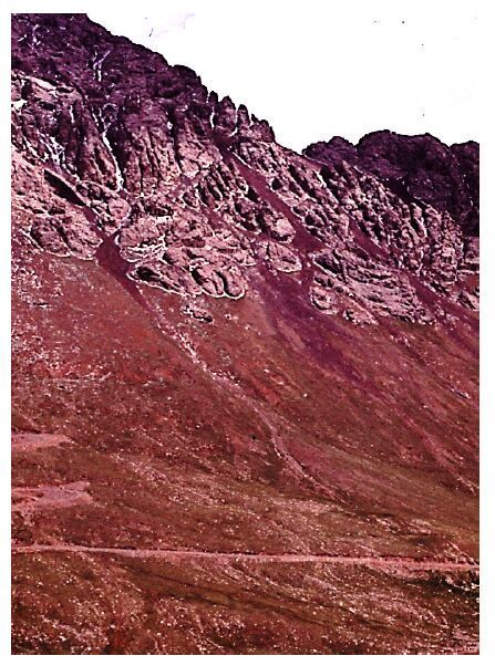
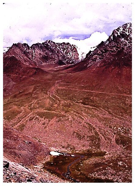
3.3 Active lag block streamsThese show a good covering of lichens on their upper surface, unlike the clean surface of the stones in active dynamic block streams. Good examples of these are found in the Chinese Tien Shan Mountains (Figures 3 and 4), near the Upper Glaciological Field Station of the former Lanzhou Institute of Glaciology and Geocryology (now called Cold and Arid Regions Environmental and Engineering Research Institute, CAREERI). There, they form wherever there is a boulder-laden till with fast-flowing water that can erode the interstitial fine material in which the boulders are embedded. This is occurring today where meltwater and runoff descend a 30° slope from bedrock above (Figure 3), or where the entire drainage from the hanging valley known as the Empty Cirque, flows down the over-steepened slope of the main valley of the Urumqi River (Figure 4). An additional area with an inactive lag block stream is present in front of a moraine on the valley floor just to the east. The moraine is low, but formed in front of a cold-based glacier with minimal sediment in the ice. It must represent a long, motionless stage of the glacier during which great quantities of meltwater eroded the interstitial sediment in the main drainage area below the moraine.
|
| Figure 3 An active lag block stream in a gully above the access road to the Upper Glaciological Field Station, Chinese Tien Shan Mountains. Note the alluvial fan on the more gently sloping land below the main cliff |
|
| Figure 4 An active lag block stream on the frontal slope of a hanging valley below the Empty Cirque above the Upper Glaciological Field Station in the Chinese Tien Shan Mountains. The drainage from the valley flows rapidly down the steep slope, eroding the interstitial sediment between the boulders in the glacial till |
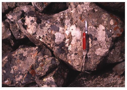
The Upper Glaciological Station is located at 43°04'N and 86°30'E, at 3, 550 m elevation. The mean annual temperature is −5.4 ℃, and the MAAT remains below 0 ℃ from September to May. The average precipitation is 420 mm/a. The active lag block streams are found between 3, 700 and 3, 800 m elevation. The resulting exposed boulders are more rounded than those found in the other active Tibetan and Siberian type block streams, and are covered in lichens (Figure 5). That would be impossible if the boulders were moving.
|
| Figure 5 Lichen-covered, subrounded to subangular boulders in part of the active lag block stream on the frontal slope below the Upper Empty Cirque in Figure 4 |
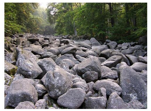
These have been reported from scattered locations on all the continents except Africa. Unlike active dynamic block streams, the boulders are often subangular to subrounded. In the case of the Odenwald rock stream at Felsen, Germany, the boulders along the margins of the stream have trees growing over them (Figure 6). A similar inactive block stream with subrounded boulders occurs at Vitosha Mountain in Bulgaria.
|
| Figure 6 Part of the inactive block stream at Odenwald, near Felsen, Germany. Note the lichens and the location along the floor of a gully, situated today on a mature, forested mountainside. This is probably a former lag block stream from which the interstitial sediment has been washed out under very different climatic conditions, probably during a glaciation. Mean shape is between 0.6 and 0.7 on the Krumbein scale, based on the measurement of 50 boulders |
Relict block streams can occur in a variety of situations. The simplest case is where the climate has changed, becoming warmer and drier. In North America, such relict block streams are found in the bottoms of gullies, and are presumed to have been active during part of the earlier glacial events, e.g., the Hickory Run boulder field in Carbon County, Pennsylvania (Smith, 1953). They are also known from Elliston, Newfoundland. Narrow boulder streams in gullies also occur in parts of the Western Cordillera, e.g., west of Laramie, Wyoming, although they have not been studied in detail. The widespread erosion and deposition during the Late Wisconsin event is presumably responsible for their rarity in Canada. Snow melt and rain may or may not continue the erosional process under the present climatic conditions, exposing more blocks, although this would also require changes in the local base level.
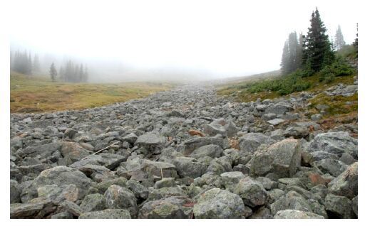
At the Marmot Basin Ski Area near Jasper, Alberta, Canada, a block stream is reappearing from beneath a thin covering of glacial till in the valley above the Middle Chalet. The lower part of the block stream has emerged completely except where the ski hill operator has put gravel over the southern margin for the access road to the upper ski lifts (Figure 7). Higher up, the till can be seen gradually being washed into the interstices of the blocks, exposing the ancient block stream. A pit excavated in the blocks exhibited about 90 cm of blocks overlying blocks with a sandy matrix. Water flows on the surface of the sand and is collected in a small dam at the snout of the block stream. The dam was built 40 years ago to supply the resort with water year-round, and the absence of a delta in the pond behind the dam suggests that there is negligible erosion of the matrix occurring at the present time. In this case, lichens are just starting to grow on the blocks.
|
| Figure 7 The relict block stream formed prior to the last glacial advance down the east-west trending valley above the Middle Chalet, Jasper National Park, Canada. Erosion has removed part of the thin covering of glacial till, and water is flowing within the block stream at a depth of about 1.5 m. Below the boulders is a clean sandy matrix. The lower limit of permafrost is about 40-50 m upslope. The water is collected behind a dam at the block stream terminus and supplies the ski resort with water throughout the year |
In the Southern Hemisphere, relict block streams have been reported from both Tasmania and the Falkland Islands. Both areas suffered limited glaciation, so the land surfaces are old and were subjected to geocryological processes during the cold periods. However, their climate has also been influenced by northward movements due to plate tectonics. Caine (1968a)carried out a detailed study of the block streams at Mount Barrow, Tasmania by digging trenches across them. At the bottom of the trenches was a layer of residual clays with pseudomorphs of dolerite rock, typical of tropical soils. This was overlain by residual clays with an admixture of sand but no pseudomorphs of cobbles, overlain by a layer of residual dolerite cobbles in yellow-brown clay above them. These deposits graded upwards into a yellow-brown silty sand with few cobbles, while above this was a layer of muck with blocks and cobbles present. Finally, at the surface was the open-work mass of blocks, ranging between 40 and 150 cm in thickness. Caine interpreted the middle layer as being the remains of a temperate soil, separated from the underlying tropical soil and the overlying blocky deposit by unconformities. Thus, the sedimentary sequence represents the results of a series of different climatic events, culminating in the formation of the block streams. Subsequently, Caine (1968b, 1972, 1983) was able to demonstrate the same range of soils from valley bottom to mountain top.
Numerous theories have been advanced about the origin of the block streams and block fields in the Falkland Islands. However, André et al. (2008) carried out a study similar to that of Caine, and found that the block streams overlie a sequence of layers similar to that found at Mount Barrow in Tasmania. It started with chemical weathering under subtropical conditions, i.e., the production of a Tertiary regolith. This was followed by a period of mass wasting and the development of a temperate forest soil. Then regolith stripping occurred with downslope accumulation and matrix removal, possibly corresponding to the Quaternary cold stages. Then periglacial reworking of the remaining blocks produced the block streams. Today, bioweathering of the boulders is producing limonite that stains the upper layers of the underlying sediments. A nearby Tertiary palaeosol was described by Halle (1911) .
The age of the surface blocks in relict block streams has also been studied using cosmogenic dating of surface blocks on slopes in the Falkland Islands (Wilson et al., 2008). The ages range back at least as far as 750 ka but are inconsistent within a given valley, varying with location on the deposit. They suggest multiple cold events causing accumulation of the angular-subangular blocks. This does not necessarily mean that the area was not glaciated. Kleman and Borgström (1990) have suggested that block fields and other blocky deposits have been preserved beneath cold-based protective ice covers in west-central Sweden, while André (2004) has described evidence for this kind of preservation in Norway. OSL dating of the fine sediments below the blocks provides age-estimates of 16-54 ka (Hansom et al., 2008). The Marmot Basin block stream in Figure 7 must predate the last ice advance at that location, though its age is not known. Thus, dating of these relict block streams is still problematic.
3.5 Surface appearance of blocky landformsUnlike rock glaciers, the surface appearance of block streams is variable. Most do have a rough surface appearance as at Odenwald (Figure 6), but others such as the block streams of the Falkland Islands have a relatively flat surface. That is why the British Army could cross them during the Falklands War with Argentina. Pissart (1992) encountered a similar problem with vertical movements of boulder pavements in streams in front of snowbanks in the French Alps. He concluded that the weight of the snowpack and associated ice pushed the boulders down into the underlying water-saturated soft sediment to produce the flat surfaces. An alternative explanation may be that of Porter (1966) , who suggested that a similar boulder ∀pavement∀ in the Anakturak Pass in the Central Brooks Range, Alaska was due to the growth of icings. One of these processes may also have taken place in the Falkland Islands at some time in the past. The same phenomenon is observed on the surface of the block streams in Newfoundland.
4 ConclusionsCryogenic block streams are relatively rare, scattered landforms reported in all continents except Africa and South America. There are three types of actively forming block streams, viz., the dynamic Siberian and Tibetan block streams, and the lag block streams. The Siberian type is found in cold continental areas with low to moderate winter snow covers, in contrast to the Tibetan type that forms in cold climates with negligible winter snow pack. These consist of positive landforms with the blocks actively moving downslope on 10°-30° slopes, but with different processes causing the movement. In contrast, in the lag block streams, the blocks do not move, but the interstitial sediment is washed out primarily by fast-flowing water.
Cryogenic block streams can also occur as relict landforms in climatic regions where they could not form today. Together with the underlying deposits, they represent a useful source of palaeoclimatic and palaeogeographic information that is only just beginning to be studied.
Acknowledgments:The author wishes to acknowledge the hospitality and logistical help provided by the former Lanzhou Institute of Glaciology and Geocryology and subsequently by the Cold and Arid Regions Environmental and Engineering Research Institute, Chinese Academy of Sciences, Lanzhou, as well as the support and encouragement of the late Academician YaFeng Shi, Academician GuoDong Cheng, and Professor HuiJun Jin. The National Research Council of Canada provided operational grants that helped with the field work in both Canada and China.
| André M-F, 2004. The geomorphic impact of glaciers as indicated by tors in North Sweden (Aarivaara, 68°N). Geomorphology, 57: 403–421. |
| André M-F, Hall K, Bertran P, et al, 2008. Stone runs in the Falkland Islands: Periglacial or tropical. Geomorphology, 95: 524–543. |
| Büdel J.1937. Eiszeitliche und rezente Verwitterung und Abtragung im chuncals nicht vereisten Gebeit Mitteleuropas. Erg. Heht 229 zu Peterm. Geogr. Mitt., Gotha. (in German). Büdel J.1937. Eiszeitliche und rezente Verwitterung und Abtragung im chuncals nicht vereisten Gebeit Mitteleuropas. Erg. Heht 229 zu Peterm. Geogr. Mitt., Gotha. (in German). |
| Caine N.1968a. The blockfields of northeastern Tasmania. Department of Geography Publication G/6. Australian National University, Canberra. Caine N.1968a. The blockfields of northeastern Tasmania. Department of Geography Publication G/6. Australian National University, Canberra. |
| Caine N, 1968b. The fabric of periglacial blockfield material on Mount Barrow, Australia. Geografiska Annaler, 50A(4): 193–206. |
| Caine N, 1972. Air photo analysis of blockfield fabrics in Talus Valley, Tasmania. Journal of Sedimentary Petrology, 42(1): 33–48. |
| Caine N, 1983. The Mountains of Northeastern Tasmania. Rotterdam: Balkema. |
| Chen JAY, 1994. Crustal movement and gravity field of the Mt. Qomolangma (Everest) and its adjacent area. Chinese Science Bulletin, 39(19): 1204–1207. |
| Čigir VG.1977. Cryogenic slope formation. In: Cryolithology Problems. Moscow: Nauka. (in Russian). Čigir VG.1977. Cryogenic slope formation. In: Cryolithology Problems. Moscow: Nauka. (in Russian). |
| Dahl R, 1966. Blockfields and other weathering forms in the Narvik Mountains. Geografiska Annaler, 48A: 224–227. |
| Darwin C, 1839. Geology and Natural History of the Various Countries Visited by H. M. S. Beagle. London: Murray. |
| Demek J.1960. Formy zvtraváni a obnosu zuluv Krumlovkeim lese jihozápadně od Brna. Čas. miner. a Geol. 5 - (in Czechoslovakian). Demek J.1960. Formy zvtraváni a obnosu zuluv Krumlovkeim lese jihozápadně od Brna. Čas. miner. a Geol. 5 - (in Czechoslovakian). |
| Glaznovskji AF, 1978. Kurums: State of knowledge and objects of investigation. Moscow: unpublished manuscript. |
| Gray J, Marquette GC, Gosse J, et al.2005. The extent, origins and age of felsenmeer surfaces of the Torngat, Kaumajet and Kiglapait Mountains of Northern Québec-Labrador, Eastern Canada. 6th International Conference on Geomorphology, Zaragoza. Abstracts Volume, pp. 8. Gray J, Marquette GC, Gosse J, et al.2005. The extent, origins and age of felsenmeer surfaces of the Torngat, Kaumajet and Kiglapait Mountains of Northern Québec-Labrador, Eastern Canada. 6th International Conference on Geomorphology, Zaragoza. Abstracts Volume, pp. 8. |
| Hack JT, Goodlett JC.1960. Geomorphology and forest ecology of a mountain region in the Central Appalachians. U.S. Gological Survey Professional Paper 347, pp. 65. Hack JT, Goodlett JC.1960. Geomorphology and forest ecology of a mountain region in the Central Appalachians. U.S. Gological Survey Professional Paper 347, pp. 65. |
| Halle TG, 1911. On the geological structure and history of the Falkland Islands. Bulletin of the Geological Institution of the University of Uppsala, 11: 115–229. |
| Hansom JD, Evans DJA, Sanderson DCW, et al, 2008. Constraining the age and formation of stone runs in the Falkland Islands using optically stimulated luminescence. Geomorphology, 94(1-2): 117–130. |
| Harris SA, 1994. Climatic zonality of periglacial landforms in mountain areas. Arctic, 46: 184–191. |
| Harris SA, 1996. Lower mean annual ground temperatures beneath a block stream in the Kunlun Pass, Qinghai Province, China. Proceedings of the 5th Chinese Permafrost Conference. Lanzhou: Institute of Glaciology and Geocryology,: 227–237. |
| Harris SA, Cheng GD, Zhao XF, et al, 1998. Nature and dynamics of an active block stream, Kunlun Pass, Qinghai Province, People's Republic of China. Geografiska Annaler, 80A(2): 123–133. |
| Hövermann J.1949. Morphologische untersuchungen im Mittelharz. Göttinger Geografisch. Abhandlungen Heft 2. (in German). Hövermann J.1949. Morphologische untersuchungen im Mittelharz. Göttinger Geografisch. Abhandlungen Heft 2. (in German). |
| Ives JD, 1966. Blockfields, associated weathering forms on mountain tops, and the nunatak hypothesis. Geografiska Annaler, 48A: 220–223. |
| Kesserli JE, 1941. Rock streams in the Sierra Nevada. Geographical Revue, 31: 203–227. |
| Klatka T.1962. Geneza i wiek goloborozy kysogórskich. Acta Geographica Lodziensia, 12. (in Polish). Klatka T.1962. Geneza i wiek goloborozy kysogórskich. Acta Geographica Lodziensia, 12. (in Polish). |
| Kleman J, Borgström I, 1990. The boulder fields of Mount Fulufjället, West-Central Sweden. Geografiska Annaler, 72A: 63–78. |
| Krumbein WC, 1941. Measurement and geological significance of shape and roundness in sedimentary particles. Journal of Sedimentary Petrology, 11: 164–172. |
| Loziński W.1912. Die periglaciale fazies der mechanischen Verwitterung. Compte Rendu, XI International Géological Congress, Stockholm, 1910. (in German). Loziński W.1912. Die periglaciale fazies der mechanischen Verwitterung. Compte Rendu, XI International Géological Congress, Stockholm, 1910. (in German). |
| Marquette GC, Gray JT, Courchesne F, et al, 2004. Felsenmeer persistence under non-erosive ice in the Torngat and Kaumajet Mountains, Quebec and Labrador, as determined by soil weathering and cosmogenic nuclide exposure. Canadian Journal of Earth Sciences, 41(1): 19–38. |
| Matsumoto S.1970. Block streams in the Kitakami Mountains - with special reference to Hitekamidake Area. Scientific Reports of Tokoka University, 7th Series (Geography), 26: 221-235. Matsumoto S.1970. Block streams in the Kitakami Mountains - with special reference to Hitekamidake Area. Scientific Reports of Tokoka University, 7th Series (Geography), 26: 221-235. |
| Matveev AP.1963. The dynamics and age of screes and stone rivers of the North Urals goletz zone in the Denezkhin Kamen massif. In: Problems of the North. Moscow: Nauka. (in Russian). Matveev AP.1963. The dynamics and age of screes and stone rivers of the North Urals goletz zone in the Denezkhin Kamen massif. In: Problems of the North. Moscow: Nauka. (in Russian). |
| Middendorf A, 1860. A Trip to the North and East of Siberia. Moscow: Nauka. |
| Ospennikov YN, 1979. Results of observations on rates of movement of stone flows of the Chulman plato. Merzlotnyye Issledovaniya, 18: 129–133. |
| Perov VF, 1969. Block fields og the khibiny Mountains. Biuletyn Peryglacjalny, 19: 381–387. |
| Pissart A, 1992. Vertical movements of boulders in a subnival boulder pavement at 2800 m a.s.l. in the Alps (France). Permafrost and Periglacial Processes, 3: 203–208. |
| Porter SC.1966. Pleistocene geology of the Anakturak Pak, Central Brooks Range, Alaska. Arctic Institute of North America Technical Paper 18. pp.100. Porter SC.1966. Pleistocene geology of the Anakturak Pak, Central Brooks Range, Alaska. Arctic Institute of North America Technical Paper 18. pp.100. |
| Rapp A, 1967. Pleistocene activity and Holocene stability of hillslopes, with examples from Scandinavia and Pennsylvania. Les Congrès et Colloques de L’Université de Liège, 40: 229–244. |
| Rea BR, Whalley WB, Rainey MM, et al, 1996. Blockfields, old or new? Evidence and implications from some plateaus in northern Norway. Geomorphology, 15: 109–121. |
| Richmond GM.1962. Quaternary stratigraphy of the La Sal Mountains, Utah. U.S. Geological Survey Professional Paper, pp. 234. Richmond GM.1962. Quaternary stratigraphy of the La Sal Mountains, Utah. U.S. Geological Survey Professional Paper, pp. 234. |
| Romanovsky NN.1985. Distribution of recently active ice and soil wedges in the USSR. In: Church M, Slaymaker O (eds.). Field and Theory: Lectures in Geocryology. Vancouver: University of British Columbia Press, pp. 154-165. Romanovsky NN.1985. Distribution of recently active ice and soil wedges in the USSR. In: Church M, Slaymaker O (eds.). Field and Theory: Lectures in Geocryology. Vancouver: University of British Columbia Press, pp. 154-165. |
| Romanovsky NN, Tyurin AI.1983. Rock stream deserption. Proceedings of the 4th International Permafrost Conference. Washington, DC: National Academy Press, pp. 1078-1082. Romanovsky NN, Tyurin AI.1983. Rock stream deserption. Proceedings of the 4th International Permafrost Conference. Washington, DC: National Academy Press, pp. 1078-1082. |
| Romanovsky NN, Tyurin AI, 1986. Kurums. Biuletyn Peryglacjalny, 31: 249–259. |
| Romanovsky NN, Tyurin AI, Sergeev DO.1989. Kurums of Bald-Mountain belt. Novosobirsk: Nauka. (in Russian). Romanovsky NN, Tyurin AI, Sergeev DO.1989. Kurums of Bald-Mountain belt. Novosobirsk: Nauka. (in Russian). |
| Smith HTU, 1953. The Hickory Run boulder field, Carbon County, Pennsylvania. American Journal of Science, 251: 625–642. |
| Tyurin AI, Romanovsky NN, Poltev NF, 1982. Frost Facies Analysis of Rock Streams. Moscow: Nauka148. |
| Washburn AL, 1979. Geocryology: A survey of Periglacial Processes and Environmemts. London: Edward Arnold406. |
| Whalley WB, Rea BR, Rainey MR, 2004. Weathering, block fields and fracture systems and the implications for long-term landscape formation: Some evidence from Lyngen and øksfjodjøkelen areas of north Norway. Polar Geography, 28(2): 93–119. |
| Whalley WB, Rea BR, Rainey MR, et al, 1997. Rock weathering in blockfields: Some preliminary data for mountain plateaus in North Norway. In: Widdowson M (ed.). Palaeosurfaces: Recognition, Reconstruction and Interpretation. Geological Society of London Special Publication, 129: 133–145. |
| White SE, 1981. Alpine mass movement forms (noncatastrophic): Classification, description and significance. Arctic and Alpine Research, 13: 127–137. |
| Wilson P, Bentley MJ, Schnabel C, et al, 2008. Stone run (block stream) formation in the Falkland Islands over several cold stages, deduced from cosmogenic isotope (10Be and 26Al) surface exposure dating. Journal of Quaternary Science, 23: 461–473. doi: 10.1002/jqs.1156 |
 2016, 8


