Article Information
- ShuSu Duan, LingKan Yao, XiaoDan Sun, Qiang Cai. 2016.
- Snow disaster characteristics in Palongzangbu River Basin and mitigation countermeasures for road engineering
- Sciences in Cold and Arid Regions, 8(2): 95-102
- http://dx.doi.org/10.3724/SP.J.1226.2016.00095
Article History
- Received: July 12, 2015
- Accepted: November 11, 2015
2. Road and Railway Engineering Research Institute, Sichuan Key Laboratory of Seismic Engineering and Technology, Chengdu, Sichuan 610031, China;
3. MOE Key Laboratory of High-speed Railway Engineering, Chengdu, Sichuan 610031, China
1 Introduction
The Sichuan-Tibet Highway passes through the Palongzangbu River Basin in Southwest China. This basin is typical of China, with high altitude and large height differential. High altitude favors more snow disasters compared to lower altitude areas, and large height differences means huge gravitational potential energy. Most snow disaster sites in this area are above the road bed, and over the long term may be damaged if the potential energy of ice and snow is converted to kinetic energy. Potential risks include avalanches, glacial lakes and glacial debris flows that are distributed at different heights above the road line. Thus, this risk should be taken into account during the process of roadconstruction using cutting-edge engineering technology.
The Palongzangbu River flows nearly from eastto west. Thus, the northern and southern valley slopes aresunny and shady slopes, respectively. The differences in hydrothermal conditions result in regular variations in vegetation, soil, topography and other natural geographic features. Therefore, environmental disasters have different distributions at different slopes(Dang, 2009).
In this paper, segmentation mitigation countermeasures are proposed based on in-depth investigation of the severity level of snow disasters and damage mode to the Sichuan-Tibet Highway.
2 Research background 2.1 TopographyIn the Palongzangbu River Basin, there are deep-cutting gorges and steep hillsides. Relative elevation difference is over 1,500 m, with the largest difference reaching 2,800 m.
In sunny slopes, there are numerous large-scale tributaries and lakes. The exogenic force comes from not only glacier movement and snow erosion, but also river erosion. Therefore, there are two types of erosion l and forms: glacial and river erosion. The estuary contains gentle slopes, where the shady slope is steeper than the sunny slope(Table 1). Nearly all tributaries are in sunny slopes, and the number of lakes in shady slopes is less than in sunny slopes(Table 1). Exogenic force types are glaciers, substantial snow and ice erosion, which then typically form glacial erosion l and forms.
| Item | Shady slope | Sunny slope |
| Basin area (km2) | 12-221 | 24-316 |
| Drainage density | A few lakes, rivers absent | Large-scale tributary, numerous lakes |
| Average slope degree | Steep, mainly 27°-39° | Multitudinous of floodplain |
The Palongzangbu River Basin contains typical maritime province glaciers in China. Temperature and rainfall changes in the basin show regulations in the vertical direction. Average annual temperature in the Suotong to Peilong segment is 10-12 ℃ or higher(Zhu et al., 1999), and decreases as one heads upstream. Annual average temperature is approximately 0 ℃ at an altitude of 4,100 m. In regions above 5,800-6,000 m, snow and modern glaciers exist throughout the year, and the temperature is below 0 ℃ all year round.
The rainy season for this basin is long, with precipitation well distributed throughout the year, and abundant in the Palongzangbu River Valley(Tibet Scientific Investigation Team of Chinese Academy of Science, 1983, 1986). Average annual rainfall is up to 1,100-1,400 mmin Tongmai, over 900 mmin Bomi, and over 700 mm in Rawu lake area(Wang, 1993). Precipitation is due to water vapor originating mainly from the Bay of Bengal, then climbs from the downstream passage of the Brahmaputral. Precipitation distribution has two obvious characteristics, namely the gradient along the main stream and the gradient from the valley to both ridges.
Maritime province glacier movement is faster than continental glacier because of abundant moisture. Also, snow and glacier disasters are more diverse than the continental glacier area.
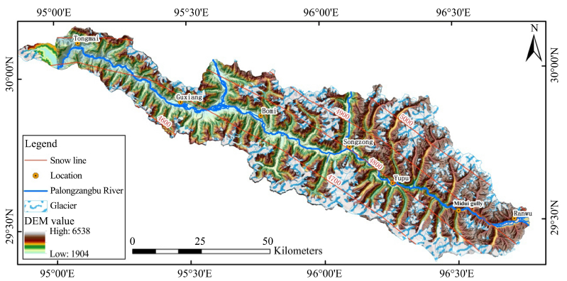
2.3 Glacier, snow line distributionThe Palongzangbu River Basin is located in the Nyainqntanglha Mountains of China. Altitude of mountain ridge and valley are between 5, 500-6, 000 m and 2, 000-3, 000 m, respectively. There are numerous snow-capped mountains and glaciers in regions above 5, 000 m(Table 2). Slopes with an altitude of 3, 000-4, 700 m are covered with seasonal snow(Wang, 1993). Distribution of glaciers(Guo, 2004; Wu and Li, 2014) and snow line are presented in Figure 1.
| Location | Number of glacier tributary | Glaciers' number and percentage | Glacier area (km2) | Glacier reserves (m3) | Average area (km2) | Average snow line height (m) | The largest glacier | |
| Area (km2) | Length (km) | |||||||
| Sunny slope | 28 | 315 (68.4%) | 364.23 (44.5%) | 228.7 (32.6%) | 1.16 | 4,986 | 14.7 | 7.5 |
| Shady slope | 39 | 146 (31.6%) | 453.41 (55.5%) | 471.9 (67.4%) | 3.11 | 4,535 | 38.11 | 12.8 |
| Total | 67 | 461 | 817.64 | 700.6 | 1.77 | 4,792 | ||

|
| Figure 1 Topography, glacier, and snow line distribution for Palongzangbu River |
From Anjou area to Bomi, the snow line altitude dropsfrom 5,200 m to 4,200 m, and reaches its lowest altitude throughout the basin in Bomi. From Bomi to Tongmai, the snow line altitude begins to rise. The snow line altitude of sunny slopes is 200-300 m higher than that of shady slopes. This phenomenon is consistent with the general rules for the northern hemisphere.
3 Characteristics of disaster distributionThe disasters which impact the Sichuan-Tibet Highway within Palongzangbu River Basin include glacial lakes, glacial debris flow and snow avalanche. The characteristics of these three disasters are investigated below.
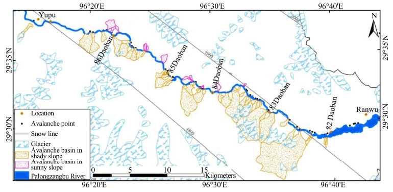
3.1 AvalancheEvery spring(February-April), the temperature risesup to 0 ℃. With the onset of long sunny days, the upper surface of the snow layer begins to melt due to a steep increase in temperature. The melt water spreads throughout the unconsolidated snow layer as a result of rapid infiltration. As the whole layer's temperature rises up to 0 ℃, there is a sudden decline of wet snow and a wet snow avalanche occurs. Almost 80% of all snow avalanches along the Sichuan-Tibet Highway are wet snow avalanches, which are large-scale and dangerous to the road. The avalanche sitesthat affect the road along the Palongzangbu River was investigated by Wang(1993), and is presented in Figure 2.Statistics in different sections are provided in Table 3.

|
| Figure 2 The distribution of snow avalanche |
| Section | Avalanche No. | Density (No./km) | Proportion (%) | Shady slope percentage (%) |
| Ranwu-Zongba | 70 | 1.3270 | 77.76 | 85.7 |
| Zongba-Zhamu | 5 | 0.0067 | 5.56 | 60.0 |
| Zhamu-Guxiang | 1 | 0.0410 | 1.11 | 0.0 |
| Total | 76 | - | 100.00 | 84.7 |
Overall, roadside avalanches originate from hillsides or watersheds. Almost all avalanches occur at upstream shady slopes, most of which are large-scale grooved avalanches. In sunny slopes, there are only a few small slope avalanches.
In certain terrain, the formation of snow avalanche occurs when daily average temperature and solid precipitation are ≤0 ℃. At an altitude of 3, 700 m, there are 145-150 days where daily average temperature is ≤0 ℃ and annual solid precipitation is 300-600 mm. The altitude of 3, 700 mis a separatrix. Theregion above the separatrix can reach the requirements for snow avalanche, such as in northern Yunan and southeastern Tibet.
Avalanche occurrence is mainly affected by accumulated snow thickness, slope gradient and bedding type. In the upstream section from Ranwu to Yupu, valley elevation is above 3,700 m, which is the required elevation for snow avalanche. About 68% of the slopes in the basin are at an angle of 30°-45°, which is ideal for forming snow avalanches. The underlying surface in the section is grass and shrubs, which is propitious to an avalanche. Therefore, the Ranwu-Yupu section is highly susceptible to avalanches compared to other sections.
Sunny slopes in the southern portion of the basin in the winter receive abundant heat due to nearly vertical irradiation of solar radiation. This heat is conducive to snow sintering, creep, and compression of whichthe snow slab becomes a higher strength snow layer. In contrast, snow surface temperature is very low in shady slopes, and there is significant temperature gradient between the ground and the snow surface. These conditions are conducive to the formation of a deep frost layer of poor cohesion by hindering snow sintering, creep, and compression. The deep frost layer always results in an avalanche slide surface.
From the aforementioned factors, most avalanches occur in upstream shady slopes.
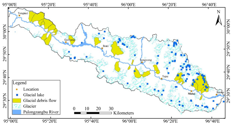
3.2 Glacial lakeThe Palongzangbu River Basin has a large number of glacial lakes due to glacier recession during the last glacial epoch. Glacial lakes' storage is steadily increasing due to increasing global temperatures, glacier retreat, glacier area reduction, and snow and ice melting. During intense ablation time, the ice bed is lubricated by infiltration water. Massive ice avalanche and l and slidesalways lead to glacial lake outburst, especially for the glacier tongue in glacial lakes. By interpreting high-resolution remote sensing images, a total of 131 glacial lakes wereidentified as presented in Figure 4(Cheng et al., 2012). Statistical regularities of glacial lakes are presented in Table 4.

|
| Figure 4 The distribution of glacial lakes and glacial debris flows |
| Feature | Sunny slope | Shady slope |
| Total number | 98 | 35 |
| Number of glacial lake (area ≥0.1 km2) | 16 | 7 |
| Total area changes of all glacial lakes | +0.345 | −0.085 |
| Elevation distribution | More than 50% are located in 4,500-5,000 m | |
More than 50% of glacial lakes are located in an area with an altitude of 4,500-5,000 m. This altitude b and coincides with the height of the snow line. Glacial lakes originate from strong melting and accumulationof snow, relatively active glaciers, and frequent advance and retreat of glaciers. Thus, numerous glacial lakes develop near the snow line.
The distances from glacial lakes to 318 National Road are presented in Figure 3. Figure 3 shows that the number of glacial lakes in sunny slopes is higher than in shady slopes for the same distance range, except fordistance range of 4,000-6,000 m. The total area of glacial lakes in sunny slopes is increasing, but decreasing in shady slopes.
3.3 Glacial debris flowSeveral glacial epochs have occurred in the Palongzangbu River Basin since the Quaternary, with vestiges of these ancient glaciers still present. There are massive diluvium resulting from chemical and biological weathering. The side end moraine and ancient periglacial deposits are well developed and abundant. This loose material is the basis for the formation of various types of debris flow. Twenty-eight debris flows were identified through on site investigation, the distribution of which is presented in Figure 4. Distribution characteristics of debris flow in sunny-shady slope are presented in Table 5. Table 5 indicates that the most serious threat of debris flow to the road is sunny slopes in the section of Guxiang to Tongmai.
| Feature | River source-Guxiang | Guxiang-Tongmai | |||
| Sunny slope | Shady slope | Sunny slope | Shady slope | ||
| Shady slope (No./km) | 0.09 | 0.03 | 0.14 | 0.04 | |
| The average basin area (km2) | 3.00 | 1.50 | 3.68 | 0.90 | |
| The average vertical degree (‰) | 221 | 180 | 310 | 204 | |
| The average relative height (m) | 2,553 | 2,840 | 3,142 | 3,063 | |
| Average distance between the confluent entrances and main river (m) | 550 | 900 | 659 | 415 | |
The direct results of glacial lake outburst are outburst floods and debris flows caused by floods. Glacial lake outburst begins with a flood, which reaches its peak discharge at the moment of a dam burst. This produces a massive amount of water flowing into the main river, causing the river level to rise rapidly, washing away hundreds of kilometers of material downstream, including villages and roads. These floods may develop into debris flow if there are massive amounts of loss material mass loose materials which often block the main river. This blockage often causes the upper reaches of the river to become submerged. A second outburst caused by mudslides always result in wider and larger secondary disaster(Cui et al., 2003).
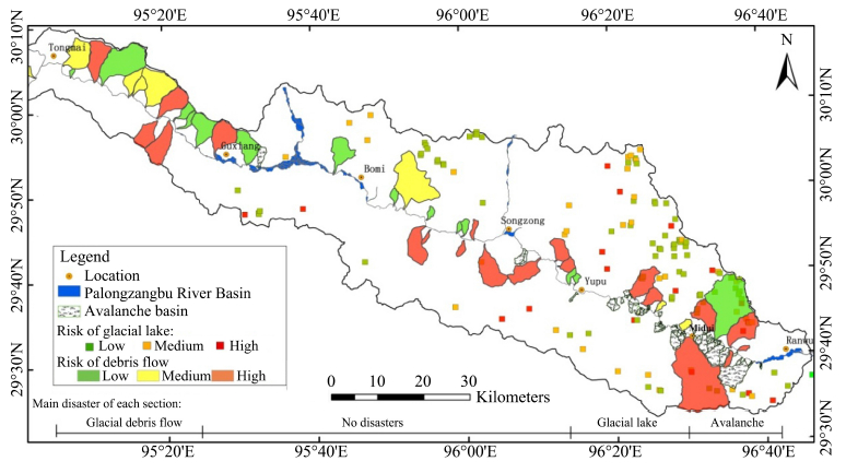
Generally, an important predisposing factor leading to glacial lake outburst is the huge surge caused by fast moving glacier, enlivened slump or fall in the glacial lake. Type, size, altitude and stability are important indicators to evaluate a lake outburst risk.The direct consequence of outburst flood is debris flood. The severity of debris flow depends on features of the channel deposit material. Therefore, eight indicators are selected to assess the risk of glacial lake outburst(Liu et al., 2012). These indicators include modern glacier area, distance between the glacier tongue and the glacial lake, average slope of snow area, glacial lake storage capacity, type, altitude, downstream channel longitudinal slope and loose material abundance. Then, the damage to the road is calculated with the weight of the distance between road and glacial lake. The severity is presented in Figure 5.

|
| Figure 5 The severity of snow avalanche, glacial lakes and glacial debris flow |
An avalanche can be roughly divided into slope avalanche and trench avalanche, according to local topography of avalanche movement route. Slope avalanchesmove on a slope and are relatively small scale. The avalanche often flows onto the road with a relatively smooth surface for a comparative long distance. A trench avalanche is a large scale collapse because of formation zone's existence. The avalanche moves quickly, carrying trees and rocks along the groove which is deposited in piles on the road. These piles are difficult to remove because they can become solidified once they stop. A trench avalanche may affect hundreds of meters of the road.
The severity descriptions of avalanche sites are collected from materials(Wang, 1993). A description and formation area size(Table 6)are used to qualitatively assess avalanche severity(Figure 5).
| ID | Location | Forming region area (km 2) | Disaster site describe |
| 1 | K3901 + 367 | 1.10 | The river is often blocked by avalanches, the road destroyed by water flooding is up to 50-150 m |
| 2 | K3905 + 200 | 0.45 | Massive avalanche pile on the slopes and river, a small amount of snow avalanche rushed to road in heavy snow year |
| 3 | K3909 + 370 | 0.30 | The river is blocked 1 or 2 times per year. The road is covered of up to 100 m. The road embankment is washed away. Snow depth on pavement is up to 10-20 m |
| 4 | K3913 + 280 | 0.51 | Every March to April, there are avalanches blocking the river and covering up roads. Bulldozers are needed 3 to 5 days to open a one-way street |
| 5 | K3919 + 480 | 0.77 | Snow avalanches rush to road in heavy snow years. Snow depth on pavement is up to 1 m, and length can be up to 150 m |
| 6 | K3920 + 730 | 0.33 | Snow avalanches rush to road in heavy snow years. Snow depth on pavement is up to 3 m, and length can be up to 40-60 m. Trees with diameter of 0.5 m can be brought to the road |
When a debris flow rushes into the main river at high speed, it may reach the opposite bank. If the flow discharge of the main river is much greater than that of the debris flow, a submerged dike may form. The flow can submerge upstream areas due to a water level rise. If blockage in the main river is severe, the flow rate in the main river increases rapidly, causing a serious hazard to the opposite shore. A dam-like blockage of the river can be formed if the debris flow discharge is much larger than that of the main river, or if solid material of debris flow is abundant. This could submerge large areas upstream, or if the debris dam breaks, large scale flooding could take place downstream. If the debris flow has enough energy to reach the opposite bank, then the main river may be diverted.
Risk of debris flow is assessed using the following indicators: the distance to the main river, the main river morphology, the main river compression level, debris flow frequency, and the main river's feature(Table 7). Quantifications of indicators are presented in Table 7, and severity of glacial debris flow is presented in Figure 5.
| No. | Influence factors | Middle weight division | ||
| Slight | Moderate | Serious | ||
| 1 | Distance to the main river (m) | >500 | 200-500 | <200 |
| 2 | Main river's morphology | Bias to the opposite shore | Straight | Bias the same shore |
| 3 | Main river's squeezed degree | No | Slight | Serious |
| 4 | Debris flow severity | Slight | Moderate | Serious |
| 5 | Mudslide frequency | No | Low frequency | High frequency |
| 6 | The characteristic of main river section | Widen gully section | Gorge section | |
In the Rawu to Midui gully section, avalanches are numerous and severe. Avalanche is the control disaster in the road design process. In shady slopes, avalanche disasters are numerous and of high severity; glacial lakes are numerous and of low severity; debris flow are less frequent and of high severity. In sunny slopes, snow avalanche and glacial lake are less frequent and of low severity; debris flow are less frequent and of high severity. The road should be built mainly in sunny slopes(right-bank). Bridges can be used to cross serious debris flows in this section. If the road is built in shady slopes, a tunnel is the best choice for avoiding disasters. Both open-cut tunnel and grid-tunnel can be used. An anti-snow corridor, energy dissipation or barrier measures are needed for large scale and high frequency trench avalanche(such as Nos. 1-3 avalanche points in Table 6).
In the Midui gully to Yupu section, glacial lakes are the largest threat to the road, and they are numerous and severe. In shady slopes, glacial lakes are less frequent and of low severity; snow avalanches are numerous and of low severity. In sunny slopes, glacial lakes are numerous and of high severity; avalanches are less frequent and of low severity. Debris flow is less frequent and of high severity for both sunny and shady slope. The road should be built mainly in shady slopes. Open-cut tunnel and grid-tunnel can be used for small scale snow avalanches. In addition, glacial lake outburst may lead to floods in the main river. Thus, the road should be elevated above flood stage.
In the Yupu to Guxiang section, all three types of ice and snow disasters are not serious. With the consideration of a wide valley and gently terrain of this section, the routing degree of freedom is relatively large, which can be chosen according to the common technical and economic conditions of the valley. Monitoring of glacial lakes in this section should be incorporated into railway operations due to dramatic changes of glacial lake volume. Once glacial lakes are found to be in a high-risk status, an artificial excavation drainage channels should be installed to eliminate the threat from glacial lake outburst.
In the Guxiang to Tongmai section, there are no glacial lake and avalanche sites, but glacial debris flows are high density and large scale. Debris flow is the control disaster. There are more debris flow sites in sunny slopes than that in shady slopes. Thus, the road should be built in shady slopes. Tunnels should be constructed in areas of large debris flows, for example of the through plan for Guxiang gully and Tianmo gully.
6 ConclusionsSnow disasters have different patterns on different slopes in the Palongzangbu River Basin. Some segmentation mitigation countermeasures for the Sichuan-Tibet Highway are presented based on the severity level of snow disaster and damage mode of the road. In the Ranwu to Midui section, snow avalanche is the controlling disaster, thus the line should be built in sunny slopes. In the Midui gully to Yupu section, the line should be built in shady slopes and elevated to reduce the risk of glacial lake outburst. In the Yupu to Guxiang section, all three snow disasters(glacial lake outburst, snow avalanche and glacial debris flows)are slight. In the Guxiang to Tongmai section, glacier debris flow becomes the major threat, therefore the road should be built in shady slopes.
Glacial lake outburst and glacial debris flow usually lead to a sequence of disasters. This sequence of disasters can cause large-scale effects in the main river. Changing the road spatial location is the first choice in these areas. Avalanche and unlikely blockage of the river by glacier debris flow are point disasters. Countermeasures for point disasters usually include changing road spatial location, point disaster improvement projects and road protection measures. One can choose the right plan through comparing the technical and economic indices.
The mitigation countermeasures proposed in this paper can provide direct references to the proposed Sichuan-Tibet Railway. The mitigation countermeasures can be used as references for projects in glacial areas.
Acknowledgments: This study is financially supported by the general project of Natural Science Foundation of China(No. 41571004); Scientific and technological research and development plan of China Railway Corporation(No. 2015G002-N); General project of Natural Science Foundation of China(No. 41172321).| Cheng ZL, Shi L, Liu JK, et al., 2012. Distribution and change of glacier lakes in the upper Palongzangbu River. Bulletin of Soil and Water Conservation, 32(5):8-12. DOI:1000-288X(2012)05-0008-05. |
| Cui P, Ma DT, Chen NS, et al., 2003. The initiation, motion and mitigation of debris flow caused by glacial lake outburst. Quaternary Sciences, 23(6):621-628. DOI:10.3321/j.issn:1001-7410.2003.06.005. |
| Dang C, 2009. The mechanics of debris flows resulting from glacier lake outburst floods(GLOFs) in southeast Tibet. Institute of Mountain Hazards and Environment, pp. 16-25. |
| Guo WQ, Liu SY, Yao XJ, et al., 2014. The Second Glacier Inventory Dataset of China(Version 1.0). Cold and Arid Regions Science Data Center at Lanzhou. |
| Liu JF, Cheng ZL, Chen XQ, 2012. The hazard assessment of glacier-lake outburst in Palongzangbu River from Ranwu to Peilong. Journal of Mountain Science, 30(3):369-377. DOI:10.16089/j.cnki.1008-2786.2012.03.017. |
| Tibet Scientific Investigation Team of Chinese Academy of Science, 1986. Glaciers in Tibet. Beijing:Science Press. |
| Tibet Scientific Investigation Team of Chinese Academy of Science, 1983. Topography of Tibet. Beijing:Science Press. |
| Wang YL, 1993. The Distribution of Snow Damage and the Principles of Privation. Beijing:Maritime Press. |
| Wu LZ, Li X, 2004. Dataset of the first glacier inventory in China.Cold and Arid Regions Science Data Center, Lanzhou. |
| Zhu PY, He ZW, Wang YC, et al., 1999. A Study of Typical Mountain Hazards along Sichuan-Tibet Highway. Chengdu:Science and Technology University Publishing House. |
 2016, 8


