Article Information
- Vladimir N. Efimenko, Sergey V. Efimenko, Alexey V. Sukhorukov. 2015.
- Accounting for natural-climatic conditions in the design of roads in western Siberia
- Sciences in Cold and Arid Regions, 7(4): 307-315
- http://dx.doi.org/10.3724/SP.J.1226.2015.00307
Article History
- Received: February 21, 2015
- Accepted: April 24, 2015
1 Introduction
The results of previous studies suggest that the quality of the design and the lifetime of roads depend heavily on the thorough underst and ing of how natural-climatic conditions of different territories can dislocate(cause structural damage to)constructed transport facilities. The diversity of climatic, soil, and hydrogeological conditions, and the terrain relief, forms a water-heating mode and significantly affects the stability of roads(Sidenko et al.,1973). In the design and construction of transport facilities, accounting for the geographic complexities is mainly accomplished by road-climatic zoning of territories(Yankovskaya et al.,2014). Such zoning of territories into areas(zones)with similar climatic conditions enhances the designing and construction of roads(Ushakov, 2005). In this regard, the whole territory of the Russian Federation is divided into road-climatic zones(RCZs). A road-climatic zone is a uniform region, characterized by typical climate conditions peculiar only to that area(Ushakov, 2005). One of the latest variants of such zoning is given in the Russian national automobile roads st and ard SNiP 2.05.02-85(SNiP, 2004) and is the result of the research carried out in the 1940s. It should be noted that the assessment of the validity of the designation of the current boundaries of the RCZs in the Asian part of Russia has been carried out only on the example of several administrative units, e.g., Moscow and Saint Petersburg.
The existing zoning methods do not take into account the diversity of natural-climatic conditions of the regions under consideration, nor all the features of the water-heating mode subgrade soil. In particular, there has been insufficient elaboration of the homogeneity and integrity criteria of the allocated districts, the rules for selecting observation elements, and the designation of boundary lines. There is also a lack of unified methods for collecting and processing of initial data, which inhibits the effective application of earlier proposed schemes for determining homogeneous territories by geographical attributes. Considerable difficulties have arisen in the comparison of or combination of zoning results obtained by different authors(Jarmolinskij et al.,2002; Efimenko S et al.,2014).
Therefore, the aim of this paper is to develop a methodological scheme for road-climatic zoning of territories using mathematical modeling of the geocomplex parameters that define features of the water-heating mode of clay soils of subgrades in various administrative units, as well to assign calculated values of strength and deformability of clay soils within the limits of the defined road districts to provide the required level of reliability of design solutions.
2 Brief information on the problem areaThe zoning of certain territories is aimed at ensuring the quality of road design. Researchers generally address problems related to this task by applying a stepwise component overlapping of spatial distributions of the zonal, azonal, intrazonal, and regional geocomplexes within a territory. Past experience in the development of road zoning principles(e.g., Russam and Coleman, 1961; Sidenko et al.,1973; Zapata and Houston, 2008)has shown that a rational account of the complex of territorial natural-climatic conditions can be based on the use of the term "road district" in the taxonomic system previously shown in the work of Sidenko et al.(1973): "zone-subzone-district-site." For example, since 1986 in Germany, RStO Directives("Guidelines for St and ardization of Superstructure of Traffic")have been applied for designation of the pavement structures of highway and urban roads(RSRT, 2001). These list typical pavement structures under a particular load for specific districts of the country, which differ in their natural-climatic conditions. In the United States, physical-geographic districts have been differentiated by the load capacity of their soilsand their change under the influence of moisture(Highway Research News, 1973), as well as by the presence of road-building materials( Efimenko S et al.,2015).
It is noteworthy that there are many terms similar to the definition of "district", which were initially reflected in the works of geographers(Smirnyagin, 2005). Within a road district, similar road structures(primarily subgrade and pavement)should be characterized by approximately the same strength and stability(Jarmolinskij et al., 2002; Efimenko S et al.,2015).
The main geocomplex feature of a "subzone" is a relief. Based on the nature of the relief, as it exists in the studied territory, the terrain is classified as flat, undulated, or mountainous. The guiding criterion in allocation of "subzones" is the morphostructure, which significantly affects the design, construction, and usage of roads(Efimenko and Badina, 2014). The term "zone" combines the subordinated terms "district" and "subzone" into a system that has a homogeneous distribution of heat and moisture, which determine the development of certain types of soilsand vegetation(Jarmolinskij et al., 2002; Efimenko S et al.,2015).
Our proposed methodological scheme for rationalizing the territorial location of boundary lines of CRZs in the system "zone-subzone-district" is based on several stages of research(Figure 1)(Efimenko and Cherepanov, 2013; Efimenko and Badina, 2014). In the first stage, a database for the modeling of geocomplex parameters is established. Among the natural and climatic conditions that must be accounted for in road-climatic zoning, Sidenko et al.(1973) and Efimenko and Badina(2014)considered three groups of factors that comprise the geographic complex: zonal, intrazonal, and regional(Figure 2). Zonal features include climatic conditions that determine the flow of the water-heating mode of subgrade soils in a region; these conditions include the average, maximum, and minimum air temperatures, the amount and seasonal distribution of precipitations, evaporation from the l and surface(Efimenko V et al., 2015), snow height, the depth and the rate of subgrade soil freezing, and the moisture content of the territory. Intrazonal natural factors can vary significantly within the limits of the area of each zone. Such features can include terrain relief and the granulometric composition of the soils. This database is developed by means of reference literature, results of field and laboratory studies, as well as theoretical modeling methods(Figure 3).
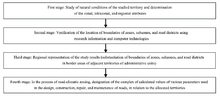 |
| Figure 1 The scheme of validating the territorial distribution of boundaries of road-climatic zones, subzones, and road districts |
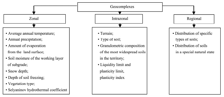 |
| Figure 2 Natural and climatic systems to be accounted for during road-climatic zoning of territories(Motylev, 1969) |
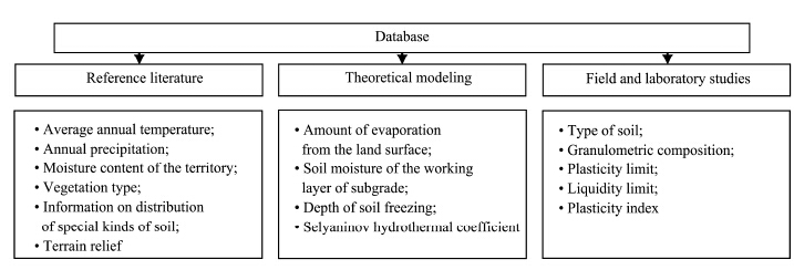 |
| Figure 3 Formation of a database for road-climatic zoning of territories |
We carried out a set of field and laboratory works in the territory of Western Siberia which enabled us to determine the composition and properties of clay soils of the working layer of the subgrade soil there. The auto road network of the region was equipped with more than 100 monitoring sites for visual and instrumental observation and for sampling of soils for further laboratory research. More than 900 soil samples from the working layer of the subgrade were selected and tested during this work.
Application of mathematical modeling methods during formation of a database for road-climatic zoning was, primarily, conditioned upon the uneven density of the road network in Western Siberia. Most of the roads are in areas with developed industry and agriculture(Lamin and Malov, 2005; Efimenko, 2006a). Therefore, field measurements of soil moisture in the working layer of the subgrade, as well as characteristics of strength and deformability, could not be performed in all areas of the region. Also, the allocation of road districts within the boundaries of the I, II, III, and IV CRZs sometimes prevented the collection of statistical information on st and ardized values of soil characteristics due to the lack of roads(Efimenko and Badina, 2014). The group of zonal geocomplexes in the database was formed from the results of forecasting parameters of the water-heating mode of roads.
For areas without provided water runoff where groundwater influences moisturing of subgrade soil we applied the earlier mathematical model proposed by Zolotar et al.(1971). Their model was refined(Efimenko, 1978)in terms of accounting for the water-heating processes in the working layer of the subgrade soils in districts characterized by excessive moisture and deep seasonal freezing.
Long-term studies of the water-heating mode of subgrades in territories of Western Siberia(CRZs II, III, and IV)carried out by specialists of the Tomsk State University of Architecture and Building(TSUAB)(MCOH, 1979)revealed that significant moisture accumulates in subgrade soils in mild winters due to an increase in the migrating moisture in frozen layers of the soil, accompanied by a decrease in the rate of propagation of the ice formation zone, up to 1.6 cm/day or less(Efimenko, 1978). In fact, this is the peculiarity of the water-heating mode of subgrade soils in districts of propagation of seasonally freezing soils in Western Siberia.
According to Zolotar et al.(1971), the essence of the method to determine the value of the calculated spring moisture of clay soils of the working layer of the subgrade is in the consequent forecasting of autumn and then spring moisture, taking into account the region-specific structure of the pavement; the elevation of the subgrade above the level of groundwater; the value of the moisture-accumulation criterion; and the thickness of the active layer in the working zone of the subgrade.
We compared the results of the theoretical solution and our field observations using the coefficient of linear correlation(r), which is a valid measure of the correlation ratio between two statistically bound attributes. Its value for the autumn relative moisture(Waut)was r = 0.86, and for the spring relative moisuture(Wspr), r = 0.89, which indicated a sufficiently high convergence of the study results carried out using different methods(Efimenko, 2006b).
For forecasting the calculated soil moisture of the working layer of the subgrade, for areas with provided water runoff where groundwater does not influence moisturing of subgrade soil, we accepted a methodology based on research findings in the southeastern part of Western Siberia(Efimenko, 1978). The methodology allows one to take into account the combined temperature- and -moisture condition of separate areas of the studied region. In this case, Equation (1) was used, as reflected in the Russian Industry Road Code ODN 218.1.052-2002(MTRF/SSPR, 2003):
| ${W_P} = \frac{{\varepsilon \cdot {K_S}}}{{\lg {\theta _V} - 1}}$ | (1) |
By analyzing the data collected during formation of the database, we could allocate four groups of factors, taking into account their influences on the territorial distribution of boundary lines of RCZs, subzones, and districts:
I: The first groupThe first group of geocomplex attributes has a decisive impact on the territorial distribution of the boundary lines of RCZs. The following factors are predominant:
• The Selyaninov hydrothermal coefficient(HTC), which characterizes the moisture of the territory, is one of the key indicators in designating the boundaries of RCZs, based on the results of the study carried out by specialists of TSUAB.
Determinations of the values of the HTC for reference points, such as in the territory of Western Siberia, correspond to the spatial distribution of RCZs. Thus, for II RCZ, HTC >1.40; for III RCZ, HTC = 1.00-1.40; and for IV RCZ, HTC = 1.00-0.50(Efimenko, 1981; Badina 2009). For districts of permafrost soil distribution(I RCZ), the Selyaninov HTC is not st and ardized(Efimenko and Badina, 2014).
• The type of vegetation(zonal group of factors)is another key indicator in designating the boundaries of RCZs. In the Russian national automobile roads st and ard SNiP 2.05.02-85*(SNiP, 2004), there are five road-climatic zones(RCZs)depending on the type of vegetation:
I RCZ: vegetation of tundra, forest tundra, and northern taiga(with distribution of permafrost soils);
II RCZ: forest vegetation(middle and southern taiga);
III RCZ: forest-steppe vegetation;
IV RCZ: steppe vegetation;
V RCZ: desert and desert-steppe vegetation.
This indicator can also be used to allocate road districts. Thus, for I RCZ in the territory of Western Siberia:
Road district 1: characterized by tundra vegetation;
Road district 2: characterized by forest-tundra vegetation;
Road district 3: characterized by northern taiga vegetation.
For II RCZ, two road districts can be allocated: middle taiga and southern taiga.
For III, IV, and V RCZs, based on this factor it is possible to allocate a zone only.
II: The second groupThe second group of attributes is recommended to use in allocation of boundary lines of subzones. The main attribute here is the characteristic exponent, the terrain relief.
• The terrain relief. Depending on the value of the relative exceedance of marks on the terrain, the terrain relief can be divided into flat(F): exceeding up to 25 m; undulating(U): exceeding from 25 m up to 200 m; and mountainous(M): more than 200 m. It should be noted that the mountainous subzone can be divided into three subzones: LM, low-mountain subzone(from 200 m up to 500 m); MM, mid-mountain subzone(from 500 m up to 1, 000 m), and HM, high-mountain subzone(over 1, 000 m)(Baranov et al.,2005).
III: The third groupThe third group of attributes is used in allocation of road districts. The following factors can be noted in its structure:
• The calculated moisture of clay soils. It is the ratio of the natural soil moisture(in approximate springtime of the year to moisture at the liquidity limit). The indicator "calculated moisture" of soils of the working layer of the subgrade serves, to a large extent, for allocation of road districtsand subjectively denotes the allocated district to an RCZ.
• The plasticity index.
• The size of soil particles(MTRF/SSPR, 1963; Kazarnovsky, 2007).
• The content of sand particles.
• Soil conditions.
• The type of soil.
IV: The fourth groupThe fourth group of attributes included into the geographical complex consolidates several indirect indicators that affect the determination of main factors, which include:
• The annual precipitation, mm.
Different literature sources usually offer different gradations of the annual precipitation; a unified classification in the literature is absent.
It shall be noted that the characteristic attribute "annual precipitation" is not determinative in allocation of road-climatic "zones-subzones-districts"; it can serve only as an indirect attribute characterizing moisture in territories, which in turn determines the type of vegetation. The latter, however, is a determining factor in allocation of RCZs(zonal group of factors).
• Evaporation from the road surface in summer months.
The indicator "evaporation from the l and surface" is used in determination of the attributes "calculated moisture" and "Selyaninov HTC."
The annual evaporation in Russian plains ranges from 150 to 200 mm in Siberian tundra provincesand up to 1, 000 mm in semi-desertsand deserts of the Caspian depression. In taiga the most characteristic evaporation rates are 450 to 500 mm, in provinces of mixed forests up to 600-700 mm, and in plains up to 800-900 mm(ProTown, 2015). The actual evaporation rates from the l and surface increase from northern to southern latitudes.
Annex M of the Russian national st and ard "Design of Railway Roadbeds with a Track Gage of 1, 520 mm"(SP 32-104-98, 1998)provides a schematic zoning map for construction, with allocated districts, which includes such indicators as "average-annual precipitation, mm" and "possible evaporation from the l and surface, mm", but these indicators characterize climatic districts only in regards to the moisture index. In cases where precipitation predominates over the evaporation, the district is referred to as "excessively moistened", but if the evaporation is higher than the average annual precipitation, that district is referred to as "arid."
• The depth of soil freezing, cm. The indicator "depth of soil freezing of the working layer of the subgrade" is required in calculating the soil moisture. It should be used when allocating road districts.
• The average annual temperature, in °C. The indicator "average annual air temperature" can(subjectively)be used in allocation of RCZsand road districts.
• The snow depth, cm. To a certain extent the indicator "snow depth" affects the moisture in the territory and can be indirectly used in allocation of road districts.
By differentiating the data in the database this way, it can be concluded that the designation of the boundary lines of RCZs is mostly affected by two indicators, the "moistening of the territory(HTC)" and "vegetation type, " as adopted in the SNiP automobile roads st and ard 02.05.02-85(SNiP, 2004). In allocation of subzones, the most crucial indicator is the "type of relief, " and allocation of road districts is affected by the composition and properties of soils presented in the working layer of the subgrade. Other factors included in the initial database are included in the group of indirect indicators. They can be taken into account only in the allocation of main factors.
The second and third stages of the work on road climatic-zoning of separate territories are aimed at clarification of the geographical distribution of boundary lines of zones, subzones, and road districts, and positioning the boundaries of districts, subzones, and zones for adjacently located territories of administrative units. This can be accomplished by either a componentwise overlapping of distribution schemes of the geocomplex elements, or with the help of mathematical methods for processing the characteristics included in the database. Because the computation algorithms under these steps are explained in detail in the works of Efimenko and Cherepanov(2013) and Efimenko V et al.(2014), we shall move on to the fourth stage of the work.
An intermediate result of this methodological scheme is a schematic map of the boundary distribution of RCZs in Western Siberia, including 14 administrative units(the Republic of Altai, the Republic of Khakassia, Altai and Krasnoyarsk Krai, Kemerovo, Kurgan, Novosibirsk, Omsk, Sverdlovsk, Tomsk, Tyumen, the Chelyabinsk region, and the Khanty-Mansi and Yamal-Nenets Autonomous Okrug). Allocated zones are divided into subzones based on the types of relief and the homogeneity of the geocomplexes; the road districts are established with a detailed characterization of the main geocomplexes. Overall, there are four RCZs recommended for Western Siberia(I, II, III, and IV), three sub-zones(F: flat, U: undulated, and M: mountainous), and 112 recommended road districts(Efimenko and Badina, 2014).
For example, in the Khanty-Mansiysk Autonomous District there are two allocated RCZs(I and II), three subzones(flat, undulated, and mountainous), and 10 road districts(from 1 to 5, depending on the zone and the subzone)(Figure 4).
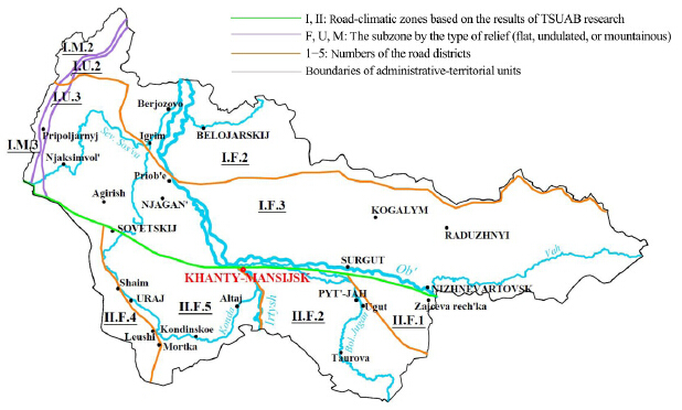 |
| Figure 4 Map of road-climatic zoning of the territory of Khanty-Mansi Autonomous District, which includes districts of permafrost soil distribution |
The fourth stage of the work is aimed at designating a complex of calculated values of moisture, strength, and deformability of clay subgrade soils to be used in the design of flexible road pavements within allocated territories in the process of road-climatic zoning.
As noted above, previous field and laboratory studies have already provided the composition and properties of soils of the working layers of the subgrades of the investigated region, which are composed mainly of clay soils, specifically silty and sandy loams, and clay loams.
Because in the studied area more than 900 samples of clay soils of the working layers of the subgrades were selected and tested, it was expedient to perform a statistical analysis of the experimental data(Efimenko, 2006b). The statistical processing included an assessment of a set of values obtained during tests for the presence of "pop-up" optionsand a check on the possibility of combining a series of tests, made for individual administrative units, into one statistical series. It was found that 3% of the experimentally obtained data had to be culled as erroneous or not relevant to the general totality.
By combining a number of observation results, the functional dependencies Еss=ƒ(WV), φss=ƒ(WV), and сss =ƒ(WV)for silty loams, light clay loams, and heavy clay loams were established. These dependencies are best approximated by the exponential curve shown in Figure 5.
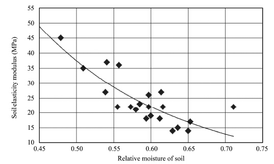 |
| Figure 5 Graph of the dependence of the elasticity modulus in clay soil(silty loam)of the subgrade on its relative moisture |
In particular, the elastic modulus of silty clay loams can be represented in the form of Equation (2):
| ${E_{ss}} = 10.92 + 3771.47{{\rm{e}}^{ - 9.76{W_V}}}$ | (2) |
The correlation ratio between the studied parameters was r = 0.92, which provided the basis for using Equation(2) to calculate the values of the elasticity modulus for loamy soils of the working layer of the subgrade in Western Siberia.
These results made it possible to recommend the values of moisture, strength, and deformability characteristics of clay soils for 112 allocated road districts in the territory of Western Siberia, in the form of tables. For example, Table 1 shows values of soil characteristics for one of the road districts in the Novosibirsk region.
| Hydraulic conductivity coefficient, K1(cm2/h) | The level of ground or surface waters from the top of the subgrade, НW(m) | Calculated values of soil indicators | |||
| Spring moisture in shares from liquid limit, WV | Elasticity modulus, Еss(MPa) | Angle of internal friction φss(°) | Specific cohesion, Сss(MPa) | ||
| 1.0 | 0.5 | 0.76 | 24 | 14.2 | 0.051 |
| 1.0 | 0.69 | 28 | 17.0 | 0.055 | |
| 1.5 | 0.61 | 33 | 21.2 | 0.061 | |
| 2.0 | 0.58 | 37 | 24.0 | 0.065 | |
| 2.5 | 0.56 | 38 | 25.2 | 0.068 | |
| 1.5 | 0.5 | 0.77 | 24 | 13.7 | 0.050 |
| 1.0 | 0.70 | 27 | 16.6 | 0.054 | |
| 1.5 | 0.62 | 33 | 21.0 | 0.060 | |
| 2.0 | 0.58 | 37 | 23.9 | 0.065 | |
| 2.5 | 0.56 | 38 | 25.2 | 0.068 | |
| 2.0 | 0.5 | 0.79 | 23 | 13.3 | 0.050 |
| 1.0 | 0.71 | 27 | 16.3 | 0.054 | |
| 1.5 | 0.62 | 32 | 20.8 | 0.060 | |
| 2.0 | 0.58 | 36 | 23.8 | 0.065 | |
| 2.5 | 0.56 | 38 | 25.1 | 0.067 | |
| 2.5 | 0.5 | 0.80 | 23 | 13.0 | 0.049 |
| 1.0 | 0.71 | 26 | 16.0 | 0.053 | |
| 1.5 | 0.62 | 32 | 20.6 | 0.060 | |
| 2.0 | 0.58 | 36 | 23.7 | 0.065 | |
| 2.5 | 0.56 | 38 | 25.1 | 0.067 | |
| 3.0 | 0.5 | 0.81 | 22 | 12.7 | 0.049 |
| 1.0 | 0.72 | 26 | 15.7 | 0.053 | |
| 1.5 | 0.63 | 32 | 20.5 | 0.060 | |
| 2.0 | 0.58 | 36 | 23.6 | 0.065 | |
| 2.5 | 0.56 | 38 | 25.1 | 0.067 | |
We propose a scientifically novel approach to identifying homogeneous territories within Russian regional administrative entities by a set of natural and climatic conditions, with a view toward regularitiesand relationships that take into account special features of the water-heating mode of subgrade soils of roadways. Our methodological scheme has been structured to specify the territorial locations of RCZs boundaries in the system "zone-subzone-district"; it includes four stages of research.
We identified and systematized the main characteristics of zonal, intrazonal, and regional geocomplexes defining the flow of the water-heating mode of the soil subgrades of roadways in the various administrative units in Western Siberia; we further used these data as a basis for the spatial allocation of zones, subzonesand road districts.
The geographical location of the boundary lines of RCZs within the administrative units has been taken into consideration, and we distinguished road districts characterized by uniform geocomplex indicators. For Western Siberia, we recommend four RCZs(I, II, III, and IV), three subzones(F: flat, U: undulated, and M: mountainous), and 112 road districts.
For each road district allocated in Western Siberia, we established and st and ardized the complex of clay soil properties needed for the design of flexible pavement based on substrate strength and deformation. The results of experimental studies on the strength and deformation characteristics of clay soils in the southern part of Western Siberia indicated differences(sometimes significant)from normalized values, as reflected, for example, in the Russian Industry Road Code ODN 218.046-01(MTRF/SSPR, 2001). Thus, the actual values of the calculated moisture content of clay soils is normalized higher by 7%-10%. The values of specific cohesion(jss)recommended by ODN 218.046-01 are overestimated by 17%-32%, as compared to the results of our actual research. The values of the specific cohesion(Сss)provided by ODN 218.046-01 for sand loams are overestimated by 14%-28%, and for clay loams are underestimated by 13%-24%. The normalized values of the elasticity modulus(Еss)of clay soils are overestimated by 25%-30%, as compared to the calculated values obtained by actual observations(Efimenko, 2006b).
Acknowledgments: The work is supported by a grant from Russian Foundation for Basic Research(Project No. 14-07-00673 A).| Badina MV, 2009. Ensuring the quality of design of road structures based on the account of regional natural-climatic conditions (on the example of Western Siberia). Ph.D.Dissertation, Tomsk State University of Architecture and Building, Tomsk (Russia), pp. 25. |
| Baranov AR, Maslak YG, Yagodintsev VI, 2005. Military Topography in the Combat Activities of Operational Units: The Textbook for Cadets and Students of Military Schools. Moscow:Mir Publishers, pp. 160. |
| Efimenko SV, 2006a. Clarification of the calculated values of characteristics of clay soils. Science and Technology in the Road Sector, 3: 28-30. |
| Efimenko SV, 2006b. Substantiation of calculated values of characteristics of clay soils for design of road pavements (for example, Western Siberia). Ph.D.Dissertation, Tomsk State University of Architecture and Building, Tomsk, pp. 217. |
| Efimenko SV, Badina MV, 2014. Road Zoning of the West Siberia Territory. Tomsk: Publishing House of Tomsk State University of Architecture and Building, pp. 244. |
| Efimenko SV, Cherepanov DN, 2013. Information systems used for road building climatic zone boundaries. Scientific and Technical Journal on Construction and Architecture, 6: 214-222. |
| Efimenko SV, Efimenko VN, Afinogenov AO, 2014. The outline of road building climatic zoning in western Siberia. Journal of Tomsk State University of Architecture and Building (Vestnik TSUAB), 1-3: 78-84 (English version appendix to Vol. 4, 2013). |
| Efimenko SV, Sukhorukov AV, KonyayevaOV, etal., 2015. Using mathematical models to provide reliability of transport facilities. In: Advanced Materials Research, Vol. 1085(2015), Proceedings from the XIth International Conference on Prospects of Fundamental Sciences Development (PFSD-2014), April 22-25, 2014, Tomsk, Russia, pp. 507-512. DOI:10.4028/www.scientific.net/AMR.1085.507. |
| Efimenko VN, 1978. Water-heating mode of subgrades with deep soil freezing (on the example of southeastern Western Siberia). Ph.D.Dissertation, The Moscow State Automobile & Road Technical University, Moscow, pp.216. |
| Efimenko VN, 1981. Road-climatic zoning of the territory of southeastern part of Western Siberia. In: KartapoltsevVM(ed.). Development of Rational Methods of Design, Construction, and Operation of Roads and Bridges. Tomsk: Publishing House of Tomsk State University, pp. 14-23. |
| Efimenko VN, Efimenko SV, Sukhorukov AV, et al., 2014. To the justification of the territorial distribution of the border II-III road-climatic zones in the Western Siberian region. Journal of Tomsk State University of Architecture and Building, 5(46): 125-134. |
| Efimenko VN, Efimenko SV, Sukhorukov AV, et al., 2015. Application of information systems in road-climatic zoning. Proceedings, IOP Conference Series: Materials Science and Engineering, 71 (2015), 012049. DOI:10.1088/1757-899X/71/1/012049. |
| Highway Research News, 1973. Filing system of physiographic units helps to resolve local design criteria. Highway Research News, 51: 42-60. |
| Jarmolinskij AI, Pichugov AP, Pugachev IN, 2002. Comprehensive approach to road building climatic zoning in the Sakhalin region.http://pnu.edu.ru/media/filer_public/2012/11/16/statja8.pdf/,accessed on Mar. 11, 2015. (in Russian) |
| Kazarnovskiy VD, 2007. Fundamentals of Engineering Geology, Soil Science, and Soil Mechanics (Short Course).Moscow: TransRoadSciPublishing, pp. 284. |
| Lamin VA, Malov VY, 2005. Problem Regions of Resource Type: Asian Part of Russia. Novosibirsk:SB RAS Publishing House, pp. 386. |
| Ministry of Construction and Operation of Highways of the RSFSR (MCOH), 1979. Methodological recommendations on designation of calculated parameters of loamy subgrade soils for design and reconstruction of the road pavement in the southeastern part of Western Siberia (Tomsk and Kemerovo region). http://www.infosait.ru/norma_doc/46/46673/index.htm/, accessed on Mar. 11, 2015. |
| Ministry of Transport of the Russian Federation, State Service of Public Roads (MTRF/SSPR), 1963. Instructions on engineering-geological survey in survey of roads. http://www.infosait.ru/norma_doc/41/41569/index.htm/, accessed on Mar. 11, 2015. |
| Ministry of Transport of the Russian Federation, State Service of Public Roads (MTRF/SSPR), 2001. Design of nonrigid pavement. ODN 218.046-01, pp. 145. |
| Ministry of Transport of the Russian Federation, State Service of Public Roads (MTRF/SSPR), 2003. Assessment of the strength of nonrigid road pavements. ODN 218.1.052-2002, pp. 80. |
| MotylevYuL, 1969. Resilience of Subgrade in Arid and Deserted Areas.Moscow:Transport Publishing, pp. 230. |
| ProTown, 2015. Average annual rainfall in Russia.http://www.protown.ru/information/hide/2850.html/, accessed on Mar. 11, 2015. |
| Research Society for Roads and Transportation (RSRT), 2001. Guidelines for Standardization of Superstructure of Traffic Areas (RStO 01). Cologne, Germany, FGSV, August 2001. |
| Russam K, Coleman JD, 1961. The effect of climatic factors on subgrade moisture conditions. Geotechnique, 11(1): 22-28. DOI: 10.1680/geot.1961.11.1.22. |
| Sidenko VM, Batrakov OT, Volkov MI, 1973. Avtomobil'nyeDorogi (SovershenstvovanieMetodovProektirovaniyaiStroitel'stva) [Highways (Improvement of Design Techniques and Construction)].Budivel'nik, Kiev, pp. 278. |
| Smiryagin PV, 2005. Key issues of zoning. Bulletin of Russian Academy of Sciences: Geography Series, 1: 5-16. |
| SP 32-104-98, 1998. Design of Earthwork for Rail Ways with 1520 mm Track. Moscow:Prosveshcheniye Publishing House OJSC (TSNIIS). |
| State Committee for Construction in the Soviet Union (SNiP), 2004. Automobile Roads. SNiP 2.05.02-85, State Committee for Construction in theSoviet Union, Moscow, pp. 56. |
| Ushakov VV, 2005. Directory of Road Terms. Moscow:Econ-InfornPublishing, pp. 256. |
| Yankovskaya A, Efimenko S, Cherepanov D, 2014. Structurization of data and knowledge for the information technology of road-climatic zoning. In: Applied Mechanics and Materials, Vol. 682 (2014), Proceedings from the 5th International Scientific Practical Conference Innovative Technologies and Economics in Engineering, May 22-23, 2014, Yurga, Russia, pp. 561-566. DOI:10.4028/www.scientific.net/AMM.682.561. |
| Zapata CE, Houston WN, 2008. Calibration and validation of the enhanced integrated climatic model for pavement design. NCHRP Report 602, National Cooperative Highway Research Program, Transportation Research Board, Washington D.C., pp. 63. |
| Zolotar IA, Puzakov NA, Sidenko VM, 1971. Water-heating Mode of Roadbeds and Pavements.Moscow:Transport Publishing Office, pp. 416. |
 2015, 7


